Canadian County, Oklahoma
Canadian County | |
|---|---|
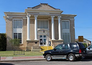
 El Reno Carnegie Library | |
 Location within the U.S. state of Oklahoma | |
 Oklahoma's location within the U.S. | |
| Coordinates: 35°32′N 97°59′W / 35.54°N 97.98°W | |
| Country | |
| State | |
| Founded | March, 1890 |
| Named for | Canadian River |
| Seat | El Reno |
| Largest city | Yukon[a] |
| Area | |
| • Total | 906 sq mi (2,350 km2) |
| • Land | 897 sq mi (2,320 km2) |
| • Water | 9.0 sq mi (23 km2) 1.0% |
| Population (2020) | |
| • Total | 154,405 |
| • Density | 170/sq mi (66/km2) |
| Time zone | UTC−6 (Central) |
| • Summer (DST) | UTC−5 (CDT) |
| Congressional districts | 3rd, 4th |
| Website | www |
Canadian County is a county in the U.S. state of Oklahoma. In 2020, 154,405 people lived there.[1] Its county seat is El Reno.
Geography[change | change source]
The county has a total area of 905 square miles.
Notes[change | change source]
- ↑ Even though Oklahoma City has a higher population, only a portion of it extends into Canadian County, which makes Yukon the most populous city entirely in the county.
References[change | change source]
- ↑ "QuickFacts: Canadian County, Oklahoma". United States Census Bureau. Retrieved January 19, 2024.

