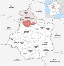
Arrondissement of Châteaudun
Châteaudun | |
|---|---|
 Location within the region Centre-Val de Loire | |
| Country | France |
| Region | Centre-Val de Loire |
| Department | Eure-et-Loir |
| No. of communes | 61 |
| Subprefecture | Châteaudun |
| Area | 1,438.8 km2 (555.5 sq mi) |
| Population (Jan. 2019)[1] | 57,999 |
| INSEE code | 282 |
The arrondissement of Châteaudun is an arrondissement of France, in the Eure-et-Loir department of the Centre-Val de Loire region. Its capital is the city of Châteaudun.
History
[change | change source]When the Eure-et-Loir department was created on 1800, the arrondissement of Châteaudun was part of that original department.[2]
Geography
[change | change source]The arrondissement of Châteaudun is the most southern of the arrondissements of the Eure-et-Loir department. It has an area of 1,438.8 km2 (555.5 sq mi) and a population of 59,794 inhabitants.
It is bordered to the north by the arrondissement of Chartres, to the east by the Loiret department, to the southeast by the Loiret department, to the south by the Loir-et-Cher department and to the west by the arrondissement of Nogent-le-Rotrou.
Composition
[change | change source]Cantons
[change | change source]After the reorganisation of the cantons in France,[3] cantons are not subdivisions of the arrondissements so they could have communes that belong to different arrondissements.
The cantons in the arrondissement of Châteaudun are:
- Brou (2803) (partly)
- Châteaudun (2807)
- Illiers-Combray (2811) (partly)
- Voves (2815) (partly)
Communes
[change | change source]The arrondissement of Châteaudun has 64 communes; they are (with their INSEE codes)ː[4]
- Alluyes (28005)
- Baigneaux (28019)
- Bazoches-en-Dunois (28028)
- Bazoches-les-Hautes (28029)
- Bonneval (28051)
- Bouville (28057)
- Brou (28061)
- Bullainville (28065)
- Bullou (28066)
- La Chapelle-du-Noyer (28075)
- Châteaudun (28088)
- Cloyes-les-Trois-Rivières (28103)
- Commune nouvelle d'Arrou (28012)
- Conie-Molitard (28106)
- Cormainville (28108)
- Courbehaye (28114)
- Dambron (28121)
- Dampierre-sous-Brou (28123)
- Dancy (28126)
- Dangeau (28127)
- Donnemain-Saint-Mamès (28132)
- Flacey (28153)
- Fontenay-sur-Conie (28157)
- Le Gault-Saint-Denis (28176)
- Gohory (28182)
- Guillonville (28190)
- Jallans (28198)
- Lanneray (28205)
- Logron (28211)
- Loigny-la-Bataille (28212)
- Lumeau (28221)
- Marboué (28233)
- Meslay-le-Vidame (28246)
- Mézières-au-Perche (28250)
- Moléans (28256)
- Montboissier (28259)
- Montharville (28260)
- Moriers (28270)
- Mottereau (28272)
- Neuvy-en-Dunois (28277)
- Nottonville (28283)
- Orgères-en-Beauce (28287)
- Péronville (28296)
- Poupry (28303)
- Pré-Saint-Évroult (28305)
- Pré-Saint-Martin (28306)
- Saint-Avit-les-Guespières (28326)
- Saint-Christophe (28329)
- Saint-Denis-les-Ponts (28334)
- Saint-Maur-sur-le-Loir (28353)
- Sancheville (28364)
- Saumeray (28370)
- Terminiers (28382)
- Thiville (28389)
- Tillay-le-Péneux (28390)
- Trizay-lès-Bonneval (28396)
- Unverre (28398)
- Varize (28400)
- Vieuvicq (28409)
- Villampuy (28410)
- Villemaury (28330)
- Villiers-Saint-Orien (28418)
- Vitray-en-Beauce (28419)
- Yèvres (28424)
The communes with more inhabitants in the arrondissement are:
| INSEE code |
Commune | Population[5] (2014) |
Canton | Intercommunality |
|---|---|---|---|---|
| 28088 | Châteaudun | 13,264 | Châteaudun | Le Grand Châteaudun |
| 28051 | Bonneval | 4,919 | Châteaudun | Le Bonnevalais |
| 28061 | Brou | 3,411 | Brou | Le Grand Châteaudun |
| 28103 | Cloyes-sur-le-Loir | 2,833 | Brou | Le Grand Châteaudun |
| 28334 | Saint-Denis-les-Ponts | 1,707 | Châteaudun | Le Grand Châteaudun |
| 28424 | Yèvres | 1,701 | Brou | Le Grand Châteaudun |
| 28012 | Commune nouvelle d'Arrou | 1,598 | Brou | Le Grand Châteaudun |
Related pages
[change | change source]References
[change | change source]- ↑ "Téléchargement du fichier d'ensemble des populations légales en 2019". The National Institute of Statistics and Economic Studies. 28 December 2020.
- ↑ "Historique d'Eure-et-Loir". Le SPLAF (in French). Retrieved 15 August 2017.
- ↑ "Décret n° 2014-231 du 24 février 2014 portant délimitation des cantons dans le département d'Eure-et-Loir" (in French). Legifrance.gouv.fr. 28 February 2014. Retrieved 15 August 2017.
- ↑ "Arrondissement de Châteaudun (282)" (in French). Institut national de la statistique et des études économiques - INSEE. Retrieved 15 August 2017.
- ↑ "Régions, départements, arrondissements, cantons et communes" (PDF). Populations légales 2014 (in French). Institut national de la statistique et des études économiques - INSEE. Retrieved 15 August 2017.
