
Beni Department
Beni
El Beni | |
|---|---|
 Llanos (plains) of Beni | |
 Flag  Coat of arms | |
| Motto(s): ¡Ventura, paz y unión! ("Venture, peace and union!") | |
| Anthem: Canta victorioso pueblo de leyenda | |
 Beni within Bolivia | |
| Created | November 18, 1842 |
| Founded by | José Ballivián |
| Capital | Trinidad |
| Government | |
| • Body | Departmental Legislative Assembly |
| Area | |
| • Total | 213,564 km2 (82,458 sq mi) |
| Elevation (average) | 155 m (509 ft) |
| Population (2012 census) | |
| • Total | 421,196 |
| • Density | 2.0/km2 (5.1/sq mi) |
| Languages | |
| • Official | Spanish, Moxeno |
| Time zone | UTC-4 (Bolivia Time) |
| Area code | + (591) 3 |
| ISO 3166 code | ISO 3166-2:BO |
| Vehicle registration | BO-B |
Beni is a department in Bolivia.[1] The capital city is Trinidad.
The department is mainly covered by rainforest and pampa. In the region's many rivers over 400 species of fish have been found. Trinidad has an entire museum, the Museo Ictícola, dedicated to Beni's fish fauna. It is the third largest of its type in South America.
Provinces of Beni[change | change source]
The department is divided into 8 provinces which are further subdivided into municipalities and 48 cantons.
Province Population
(2012 census)Area (km²) Capital Map Cercado 111,624 12,276 San Javier 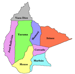
Vaca Díez 130,778 22,434 Riberalta José Ballivián 82,700 40,444 Santos Reyes Yacuma 23,430 34,686 Santa Ana del Yacuma Moxos 22,163 33,316 San Ignacio de Moxos Marban 16,331 15,126 Loreto Mamoré 12,817 18,706 San Joaquín Iténez 21,353 36,576 Magdalena

Places of interest[change | change source]
- Beni Biological Station Biosphere Reserve
- Isiboro Sécure National Park and Indigenous Territory
- Cachuela Esperanza
- Pilón Lajas Biosphere Reserve and Communal Lands
References[change | change source]
- ↑ "The World Factbook". CIA. Archived from the original on 2018-12-25. Retrieved 2020-03-28.