Benson, Oxfordshire
| Benson | |
|---|---|
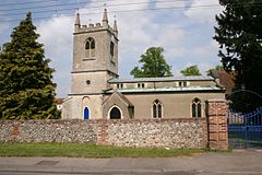
 St Helen's parish church | |
| Location within Oxfordshire | |
| Area | 9.84 km2 (3.80 sq mi) |
| Population | 4,754 (2011 Census) |
| • Density | 483/km2 (1,250/sq mi) |
| OS grid reference | SU6191 |
| Civil parish |
|
| District | |
| Shire county | |
| Region | |
| Country | England |
| Sovereign state | United Kingdom |
| Post town | Wallingford |
| Postcode district | OX10 |
| Dialling code | 01491 |
| Police | Thames Valley |
| Fire | Oxfordshire |
| Ambulance | South Central |
| UK Parliament | |
Benson is a village and civil parish in South Oxfordshire, England. In 2011, the population was 4,754.[2]
References[change | change source]
- ↑ "Benson Parish Council Website". Benson Parish Council. Retrieved 20 July 2021.
- ↑ "Area: Benson (Parish): Key Figures for 2011 Census: Key Statistics". Neighbourhood Statistics. Office for National Statistics. Archived from the original on 17 November 2015. Retrieved 14 November 2015.

