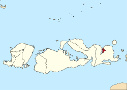
Bima
Bima
Mbojo | |
|---|---|
 A bus on the street in the City of Bima at noon. | |
| Motto(s): Maja Labo Dahu (Bima) (Shame and Fear) | |
 Bima in West Nusa Tenggara | |
Bima in Lesser Sunda Islands and Indonesia | |
| Coordinates: 08°27′36″S 118°43′36″E / 8.46000°S 118.72667°E | |
| Country | |
| Province | |
| Region | Lesser Sunda Islands |
| Government | |
| • Mayor | Muhammad Lutfi |
| • Vice Mayor | Fery Sofiyan |
| Area | |
| • Total | 222.25 km2 (85.81 sq mi) |
| Population (2014) | |
| • Total | 148,984 |
| • Density | 670/km2 (1,700/sq mi) |
| Time zone | UTC+8 (Indonesia Central Time) |
| Area code | (+62) 374 |
| Vehicle registration | EA |
| Website | www.bimakota.go.id |
Bima (Indonesia: Kota Bima) is a city on the eastern coast of the island Sumbawa. It is in the central Indonesian province called West Nusa Tenggara. It is the largest city on the island. The population was 142,443 at the 2010 Census. It is not part of the Regency of Bima which had a population of 407,636 at the 2010 Census.
History
[change | change source]
From 1620 to 1958 it was the capital of the Bima Sultanate, one of the four sultanates on Sumbawa. Today, Bima is the largest regional and economic center of Eastern Sumbawa. People from other parts of Indonesia, especially Java, Bali, and Lombok came to live in the city.
People
[change | change source]The majority of the people in Bima are Muslims (97.38%). The rest are Protestant (0.89%), Catholic Christians (0.62%), and Hindus and Buddhists around (1.11%). The people of Bima and all of east Sumbawa speak Bima language.
Place
[change | change source]The city is on the eastern shore of Bima Bay. Bima is on the Sumbawa road. Sape harbor is to the east and Dompu to the southwest. Historically, Bima was a port city that connected to other port cities in Eastern Indonesia such as Makassar and Ternate, and to ports in Lombok, Bali, and East Java. Bus services from Bima go to neighboring cities in Sumbawa and as far as Mataram in Lombok.
Airport
[change | change source]Sultan Muhammad Salahudin Airport (Bima Airport),[1] is about 10 kilometres (6.2 mi) south of the city.
| Airlines | Destinations |
|---|---|
| Garuda Indonesia | Ngurah Rai International Airport, Denpasar, Bali |
| NAM Air | Ngurah Rai International Airport, Denpasar, Bali,[2] Lombok International Airport, Mataram, Lombok[3] |
| Susi Air | Komodo Airport, Labuan Bajo, Mau Hau Airport, Waingapu |
| Wings Air | Ngurah Rai International Airport, Denpasar, Bali Lombok International Airport, Mataram, Lombok, Sultan Hasanuddin International Airport, Makassar |
Administration
[change | change source]
Bima has 5 districts (kecamatan):
Tourism
[change | change source]
Bima has several popular tourist destinations, such as Mount Tambora, Wawo traditional Village, Snake Island, Ana Fari Lake, and Satonda Island. There are many white sandy beaches in north and sout Bima. The main attractions are the Sultan Salahuddin Mosque and Sultan Salahuddin Museum. The museum used to be the Bima Sultanate palace. Bima airport serves domestic and international visitors
Sister cities
[change | change source]References
[change | change source]- ↑ Airport information for WADB - Muhammad Salahuddin Airport - Bima, Indonesia at World Aero Data. Data current as of October 2006.
- ↑ "Sriwijaya Air :: Your Flying Partner :: Online Booking & Payment - Tiket dan Penerbangan Murah - Penerbangan Domestik dan Internasional - One of Indonesian Leading Airline - e-Ticket Purchase | Sriwijaya Air". Archived from the original on 2016-02-05. Retrieved 2019-11-23.
- ↑ "Instagram".
Other websites
[change | change source]- Official website
- RoyalArk- Indonesia- Bima
- Bima Wordlist at the Austronesian Basic Vocabulary Database
- Hägerdal, Hans (2017). Held's History of Sumbawa. Amsterdam University Press. doi:10.2307/j.ctv157bn1. ISBN 9789462981614. JSTOR j.ctv157bn1.
8°27′36″S 118°43′36″E / 8.46000°S 118.72667°E


