
Braunau am Inn
Braunau am Inn | |
|---|---|
 Braunau town centre | |
 Coat of arms | |
 Braunau am Inn Location within Austria | |
| Coordinates: 48°15′30″N 13°2′6″E / 48.25833°N 13.03500°E | |
| Country | Austria |
| State | Upper Austria |
| District | Braunau am Inn |
| Government | |
| • Mayor | Johannes Waidbacher (ÖVP) |
| Area | |
| • Total | 24.84 km2 (9.59 sq mi) |
| Elevation | 352 m (1,155 ft) |
| Population (2018-01-01)[2] | |
| • Total | 17,095 |
| • Density | 690/km2 (1,800/sq mi) |
| Time zone | UTC+1 (CET) |
| • Summer (DST) | UTC+2 (CEST) |
| Postal code | 5280, 5282A |
| Area code | 07722 |
| Vehicle registration | BR |
| Website | www |
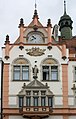
Braunau am Inn is a town in the Innviertel region of Upper Austria (Oberösterreich), the north-western state of Austria. It lies about 90 km west of Linz and about 60 km north of Salzburg, on the border with the German state of Bavaria. It has a continental climate (Dfa in the Koeppen climate classification). The population in 2001 was 16,372. A port of entry, it is connected by bridges over the Inn River with its Bavarian counterpart, Simbach am Inn. It is the birthplace of Adolf Hitler. It was in the American Occupation Zone of Austria from 1945 to 1955 .
- Braunau am Inn
-

-
-
 Hitler's birthplace
 -

-
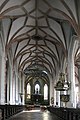
 St. Stephan
 -

-
-


References[change | change source]
- ↑ "Dauersiedlungsraum der Gemeinden Politischen Bezirke und Bundesländer - Gebietsstand 1.1.2018". Statistics Austria. Retrieved 10 March 2019.
- ↑ "Einwohnerzahl 1.1.2018 nach Gemeinden mit Status, Gebietsstand 1.1.2018". Statistics Austria. Retrieved 9 March 2019.
| International | |
|---|---|
| National | |
| Geographic | |
| Other | |