
Clervaux
Clervaux
Klierf | |
|---|---|
 General view of Clervaux. | |
 Coat of arms | |
 Map showing, in orange, the Clervaux commune | |
| Coordinates: 50°03′0″N 6°02′0″E / 50.05000°N 6.03333°E | |
| Country | |
| Canton | Clervaux |
| Commune | Clervaux |
| Government | |
| • Mayor | Emile Eicher |
| Area | |
| • Total | 85.0 km2 (32.8 sq mi) |
| Highest elevation | 544 m (1,785 ft) |
| Lowest elevation | 274 m (899 ft) |
| Population (2017)[2] | |
| • Total | 5,069 |
| • Density | 60/km2 (150/sq mi) |
| Time zone | UTC+1 (CET) |
| • Summer (DST) | UTC+2 (CEST) |
| LAU2 | LU00001001 |
| Website | Official website |
Clervaux (Luxembourgish: Klierf, German: Clerf) is a commune and town in northern Luxembourg, administrative capital of the canton of Clervaux.
The city is in the valley of the Clerve river and is part of the Natural Park of the Our.
History[change | change source]
The city was the site of heavy fighting during World War II, in the December 1944 Battle of Clervaux, part of the "Battle of the Bulge".
In 2012, the commune of Clervaux was combined with the communes of Heinerscheid and Munshausen.
-
 Clervaux before 2012
 -
 Heinerscheid
 -
 Munshausen
 -
 Clervaux in 2012


Geography[change | change source]
The commune is in the Oesling, a region within the greater Ardennes area. It has an area of 85 km2 (32.8 sq mi).[1]
The highest point in the commune is in Schwaarzenhiwwel near the town of Marnach that is 544 m (1,785 ft) high, and the lowest point is 274 m (899 ft) high that is in the valley of the Our river near the town of Roder.[3] The altitude is 208–428 m (682–1,404 ft) high. At the railway station, the altitude is 360 m (1,180 ft) high.[4]
To the east, the Our river forms the border with Germany and, to the north, is the commune borders Belgium. In this commune is the place where three countries meetː Luxembourg, Germany and Belgium.
Places next to Clervaux | ||||||||||
|---|---|---|---|---|---|---|---|---|---|---|
| ||||||||||
Population[change | change source]
There were 5,069 persons living in the commune in 2017,[2] for a population density of 59.6 inhabitants/km².
Other towns, besides the town of Clervaux, within the commune are:
- Drauffelt (Draufelt)
- Eselborn (Eeselbur)
- Fischbach (Fëschbech)
- Grindhausen (Grandsen)
- Heinerscheid (Hengescht)
- Hupperdange (Hëpperdang)
- Urspelt (Ischpelt)
- Kalborn (Kaalber)
- Lieler (Léiler)
- Marnach (Maarnech)
- Mecher (Mecher)
- Munshausen (Munzen)
- Reuler (Reiler)
- Roder (Rueder)
- Siebenaler (Siwwenaler)
- Weicherdange (Wäicherdang)
Evolution of the population in Clervaux

Places of interest[change | change source]
- The Clervaux Castle. Here is on permanent display The Family of Man, a famous exhibit of photos collected by Edward Steichen. The castle also includes the Battle of the Bulge Museum, with an extensive collection of objects from World War II, and an exhibition of models of the castles and palaces of Luxembourg.
- The Abbey of St. Maurice and St. Maur is situated close to the town of Clervaux. Halldór Laxness, 1902–1998, the Nobel Prize-winning Icelandic writer, stayed at the abbey for some time.
- Church of Saints Cosmas and Damian, built in the years 1910-1912.
Gallery[change | change source]
-
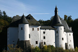 Castle of Clervaux
 -
 Castle of Clervaux
 -
 Abbey of St. Maurice and St. Maur
 -
 Saints Cosmas and Damian church
 -
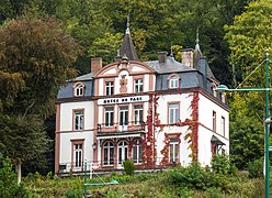 Hôtel du Parc in Clervaux.


Related pages[change | change source]
References[change | change source]
- ↑ 1.0 1.1 "Surface area of the cantons and municipalities". Statistics Portal - Grand Duchy of Luxembourg. Retrieved 27 May 2016.
- ↑ 2.0 2.1 "Population by canton and municipality 1821 - 2017". Statistics Portal - Grand Duchy of Luxembourg. Retrieved 30 December 2017.
- ↑ "La commune de Clervaux: Situation géographique" (PDF) (in French). clervaux.lu. Retrieved 26 May 2016.
- ↑ "Altitudes of the different localities per cantons (in m)". Statistics Portal - Grand Duchy of Luxembourg. Retrieved 10 June 2016.
Other websites[change | change source]
- Official website (in French)
- Destination Clervaux Archived 2013-07-20 at the Wayback Machine
- Château fort de Clervaux Archived 2011-07-22 at the Wayback Machine (in French)
- Abbaye Saint-Maurice-et-Saint-Mau (in French)