
Doubs (river)
| Doubs Dubs (Arpitan) Dub (German) | |
|---|---|
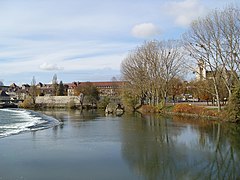
 The Doubs upstream of Besançon, amid richly-forested high hills | |
 | |
| Location | |
| Countries | |
| Physical characteristics | |
| Source | |
| - location | Mouthe, Jura mountains |
| - coordinates | 46°42′17″N 6°12′34″E / 46.70472°N 6.20944°E |
| - elevation | 946 m (3,104 ft) |
| Mouth | |
| - location | Saône |
| - coordinates | 46°54′3″N 5°1′27″E / 46.90083°N 5.02417°E |
| - elevation | 175 m (574 ft) |
| Length | 453 kilometres (281 mi) |
| Basin size | 7,500 km2 (2,900 sq mi) |
| Discharge | |
| - average | 176 m3/s (6,200 cu ft/s) |
| Basin features | |
| Tributaries | |
| - left | Loue |
| - right | Allan |
| Lakes | Lac de Saint-Point, Lac des Brenets, Lac de Moron |
| gender (masculine: preceded by le/du) | |
The Doubs is a river in eastern France and western Switzerland. It is a left tributary of the Saône river that flows through the Bourgogne-Franche-Comté region and the French-speaking Switzerland.
The Doubs department is named after this river.
Geography[change | change source]
The Doubs river has a length of 453 km (281.5 mi) and a drainage basin with an area of 7,710 km2 (2,977 sq mi).[1]
Its average yearly discharge (volume of water which passes through a section of the river per unit of time) is 173 m3/s (6,100 cu ft/s) at Neublans-Abergement, a commune in the Jura department near the confluence of the Doubs and the Saône.[2]

Average monthly discharge (m3/s) at Neublans-Abergement (52 years)[2]
Course[change | change source]
The Doubs river starts in the commune of Mouthel in the Doubs department, at an altitude of about 937 m (3,074 ft) in the Jura Mountains near the French-Swiss border.[3] Then it flows to the northeast and pass through the Lac de Saint-Point lake and forms the border between France and Switzerland for several kilometres before going into Switzerland, into the canton of Jura, in the region known as Clos du Doubs. The waterfall named as Saut du Doubs on the French-Swiss border. Then the river turns to the west and gets back into France. Finally, the river flows to southwest to join the Saône river.
The Doubs river flows through one region and three departments in France, and two cantons (Neuchâtel and Jura) in Switzerland. It flows through the following communes, among others:[1]
- Bourgogne-Franche-Comté region (first part)
- Switzerland: Saint-Ursanne in the Jura canton
- Bourgogne-Franche-Comté region (second part)
-
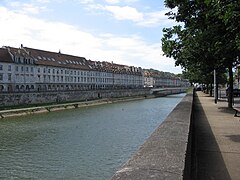 Besançon.
 -
 Morteau.
 -
 Dole.
Dole. -
 Mouthe.


.jpg)

The river forms several lakes:
- Lac des Brenets (elevation: 750 m [2,460 ft])
- Lac de Moron (elevation: 716 m [2,349 ft])
- Lac de Biaufond (elevation: 610 m [2,000 ft])
The Doubs river flows into the Saône river as a leftt tributary in the city of Verdun-sur-le-Doubs.[4]
Main tributaries[change | change source]
The main tributaries, over 30 km long, of the Doubs river are:[1]
|
Left tributaries:
|
|
Right tributaries:
|
Hydroelectricity[change | change source]
The Doubs is used for electricity generation (hydroelectricity). Among several hydroelectric stations, the most important are the Dam of Châtelot, 74 m (243 ft) tall, and the Dam of Refrain, 66.5 m (218 ft) tall.
Gallery[change | change source]
-

-
 The Saut du Doubs.
 -
 The Lac des Brenets.
 -
 The Doubs in Dole.
 -
 Confluence of Saône (left) and Doubs (right) rivers.


Related pages[change | change source]
References[change | change source]
- ↑ 1.0 1.1 1.2 "Le Doubs (U2--0200)" (in French). SANDRE - Portail national d'accès aux référentiels sur l'eau. Retrieved 25 June 2017.
- ↑ 2.0 2.1 "Le Doubs à Neublans-Abergement". Banque Hydro (in French). Ministère de l'Ecologie, du Développement Durable et de l'Energie. Archived from the original on 22 November 2021. Retrieved 25 June 2017.
- ↑ "Source du Doubs" (in French). Géoportail. Retrieved 25 June 2017.
- ↑ "Embouchure du Doubs" (in French). Géoportail. Retrieved 25 June 2017.