
Fernando de Noronha
Fernando de Noronha (Portuguese pronunciation: [feʁˈnɐ̃du d(ʒ)i noˈɾoɲɐ]) is an archipelago in the Atlantic Ocean, 354 km (191 nmi; 220 mi) off the Brazilian coast. It consists of 21 islands and islets, extending over an area of 26 km2 (10 sq mi).[1] Only the main island is inhabited. It has an area of 18.4 km2 (7.1 sq mi) and a population estimated at 3,101 in 2020. Most of the archipelago is low-lying, but there are some parts that reach 100 m (328 ft) in elevation.
The archipelago is part of the State of Pernambuco, Brazil.
The islands are administratively unique in Brazil. They form a "state district" (Portuguese: distrito estadual) that is administered directly by the government of the state of Pernambuco (even though they are closer to the state of Rio Grande do Norte).[2] The state district's jurisdiction also includes the very remote Saint Peter and Saint Paul Archipelago, located 625 km (337 nmi; 388 mi) northeast of Fernando de Noronha. Seventy percent of the islands' area was established in 1988 as a national marine park.
In 2001, UNESCO made it a World Heritage Site because of its importance as a feeding ground for tuna, sharks, turtles, and marine mammals.[3] Its time zone is UTC−02:00 all year round.
References[change | change source]
- ↑ "Fernando de Noronha". www.noronha.pe.gov.br. Archived from the original on 2019-12-29. Retrieved 2022-09-07.
- ↑ Government of the State of Pernambuco. "Administração Geral de Fernando de Noronha" [General Administration of Fernando de Noronha] (in Portuguese). Archived from the original on 2019-03-29. Retrieved 2017-06-03.
- ↑ "Brazilian Atlantic Islands: Fernando de Noronha and Atol das Rocas Reserves". UNESCO World Heritage List. Retrieved 21 March 2021.
Gallery[change | change source]
-
 Map of the Archipelago
 -
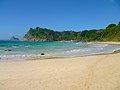
 Fernando de Noronha Conceição beach
 -
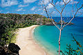
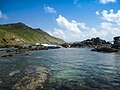
 Landscape in Fernando de Noronha
 -
 Historic fortifications
 -
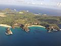 Aerial view
 -
 Fernando de Noronha beach
 -
 Crystalline water
 -
 Underwater
 -
 Sancho Bay
 -
 Spinner dolphins in Dolphin Bay
 -
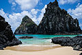
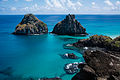 Two Brothers Rock (Morro Dois Irmãos)
 -
 Cacimba do Padre
 -
 Cacimba do Padre Beach
 -
 Ponta da Sapata
 -
 Two Brothers Rock
 -
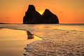 Sunset
 -
 Fernando de Noronha snorkeling
 -
 Fernando de Noronha beach Sancho Bay

.jpg)
.jpg)


.jpg)


.jpg)