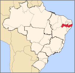
Pernambuco
State of Pernambuco | |
|---|---|
 Location of State of Pernambuco in Brazil | |
| Coordinates: 8°20′S 37°48′W / 8.333°S 37.800°W | |
| Country | |
| Capital and Largest City | Recife |
| Government | |
| • Governor | Paulo Câmara |
| • Vice Governor | Luciana Santos |
| • Senators | Fernando Bezerra Coelho (MDB) Humberto Costa (PT) Jarbas Vasconcelos (MDB) |
| Area | |
| • Total | 98,311.616 km2 (37,958.327 sq mi) |
| • Rank | 19th |
| Population (2012)[1] | |
| • Total | 8,931,028 |
| • Rank | 7th |
| • Density | 91/km2 (240/sq mi) |
| • Rank | 6th |
| Demonym | Pernambucano |
| GDP | |
| • Year | 2007 estimate |
| • Total | R$ 32.255.687 (10th) |
| • Per capita | R$ 4.337 (21st) |
| HDI | |
| • Year | 2005 |
| • Category | 0.718 – Low (23rd) |
| Time zone | UTC-3 (BRT) |
| • Summer (DST) | UTC-2 (BRST) |
| Postal Code | 50000-000 to 56990-000 |
| ISO 3166 code | BR-PE |
| Website | pe.gov.br |
Pernambuco is a state of Brazil. The capital city of the state is Recife. About 8 million people live in Pernambuco with 1.5 million of those living in Recife. The economy is largely based on agriculture, its main exports are sugar cane and manioc. It has a mainly tropical climate.
References[change | change source]
| States of Brazil | |
|---|---|
| Acre | Alagoas | Amapá | Amazonas | Bahia | Ceará | Espírito Santo | Goiás | Maranhão | Mato Grosso | Mato Grosso do Sul | Minas Gerais | Pará | Paraíba | Paraná | Pernambuco | Piauí | Rio de Janeiro | Rio Grande do Norte | Rio Grande do Sul | Rondônia | Roraima | Santa Catarina | São Paulo | Sergipe | Tocantins | |
| Federal district: Distrito Federal | |


