
Paraná (state)
State of Paraná | |
|---|---|
 Flag  Coat of arms | |
 Location of State of Paraná in Brazil | |
| Coordinates: 24°0′S 51°0′W / 24.000°S 51.000°W | |
| Country | |
| Capital and Largest City | Curitiba |
| Government | |
| • Governor | Ratinho Junior |
| • Vice Governor | Darci Pina (PSD) |
| Area | |
| • Total | 199,314.9 km2 (76,955.9 sq mi) |
| • Rank | 9th |
| Population (2012)[1] | |
| • Total | 10,577,755 |
| • Rank | 6th |
| • Density | 53/km2 (140/sq mi) |
| • Rank | 12th |
| Demonym | Paranaense |
| GDP | |
| • Year | 2006 estimate |
| • Total | R$ 136,681,000,000 (5th) |
| • Per capita | R$ 13,158 (7th) |
| HDI | |
| • Year | 2011 |
| • Category | 0.823 – high (7th) |
| Time zone | UTC-3 (BRT) |
| • Summer (DST) | BRST |
| Postal Code | 80000-000 to 86990-000 |
| Area code | 41 to 44 |
| ISO 3166 code | BR-PR |
| Website | pr.gov.br |
Paraná is a state in Southern Brazil. It is next to Paraguay and Argentina. Its capital is Curitiba. Paraná is a famous state because of Itaipu Dam and the Iguaçu Falls.
Paraná is bounded on the north by São Paulo, on the east by the Atlantic Ocean, on the south by Santa Catarina and the Misiones Province of Argentina, and on the west by Mato Grosso do Sul and the republic of Paraguay, with the Paraná River as its western boundary line.
Paraná is one of the Brazilian states that shows the most signs of recent European colonization. Most of the population are descendants of European settlers, and is one of the most ethnically diverse. Waves of European immigrants started arriving after 1850, mainly Germans, Italians, Poles and Ukrainians. The development of the state is closely linked to the arrival of the immigrants. Nowadays, migrants from other Brazilian states (especially from the São Paulo, Santa Catarina, Rio Grande do Sul and the Northeast Region) come to Paraná in search of a better life.
People of Polish descent predominate in the central and south regions, mainly around Curitiba. Italians predominate in the capital, Curitiba, and in the coast. People of Ukrainian descent predominate in a few cities, such as Prudentópolis; many Ukrainians are found throughout the state. Germans predominate in a few cities, such as Rolândia. Almost all towns have many Portuguese people and their descendants.
People of mixed-race ancestry predominate in a few towns in the north. There is an important Muslim Lebanese and Syrian community around Foz do Iguaçu. In the north, there are many Japanese people.
The main cities of the state are:
- Curitiba (Capital and largest, east)
- Londrina (2nd largest, north)
- Maringá (3rd largest, north)
- Foz do Iguaçu (4th largest, west)
- Ponta Grossa (5th largest, center-east)
- Cascavel (6th largest, center-west)
- São José dos Pinhais (7th largest, Greater Curitiba)
- Colombo (8th largest, Greater Curitiba)
- Guarapuava (9th largest, center)
- Paranaguá (10th largest, east-coast)
Album[change | change source]
-

-
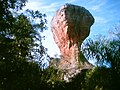
 Pico Paraná, the highest mountain in the Southern Brazil
 -
-
 The largest dam of the world was built and one of Seven Wonders of the Modern World, the Hidroelétrica de Itaipu, in Foz do Iguaçu
 -
 State Park of Vila Velha, with great rocky formations sculptured by the erosion of rain and wind, in Ponta Grossa
 -
 Azure Jay, the state bird of Paraná
 -
 The Universidade Federal do Paraná - UFPR ("Federal University of Paraná") is the oldest Brazilian university
 -
 Brejatuba beach
 -
 Ukrainian Memorial in Curitiba
 -

-
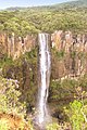 Saint Francis Waterfall, the largest falling water in Southern Brazil


References[change | change source]
Other websites[change | change source]
- Official website (in Portuguese)
| States of Brazil | |
|---|---|
| Acre | Alagoas | Amapá | Amazonas | Bahia | Ceará | Espírito Santo | Goiás | Maranhão | Mato Grosso | Mato Grosso do Sul | Minas Gerais | Pará | Paraíba | Paraná | Pernambuco | Piauí | Rio de Janeiro | Rio Grande do Norte | Rio Grande do Sul | Rondônia | Roraima | Santa Catarina | São Paulo | Sergipe | Tocantins | |
| Federal district: Distrito Federal | |
| International | |
|---|---|
| National | |
| Geographic | |
| Other | |