
South Region, Brazil
South Region
Região Sul | |
|---|---|
 | |
| Coordinates: 25°26′S 49°16′W / 25.433°S 49.267°W | |
| Country | |
| States | Paraná, Rio Grande do Sul, Santa Catarina |
| Area | |
| • Region | 576,409.6 km2 (222,553.0 sq mi) |
| • Rank | 5th |
| Population | |
| • Region | 30,192,315 |
| • Rank | 3rd |
| • Density | 52/km2 (140/sq mi) |
| • Rank | 2nd |
| • Urban | 82% |
| GDP | |
| • Year | 2008[1] |
| • Total | R$676 billion (2nd) |
| • Per capita | R$ 24,382 (2nd) |
| HDI | |
| • Year | 2017 |
| • Category | 0.798 – high (1st) |
| • Life expectancy | 77.2 years (1st) |
| • Infant mortality | 7.7 per 1,000 (5th) |
| • Literacy | 98.3% (1st) |
| Time zone | UTC−03:00 (BRT) |
The South Region of Brazil (Portuguese: Região Sul do Brasil) is one of the five geographical regions of Brazil defined by the Brazilian Institute of Geography and Statistics in 1969. It includes the states of Paraná, Santa Catarina and Rio Grande do Sul.
Geography[change | change source]
The South Region has an area of 576,774.31 km2 (222,693.81 sq mi), the smallest region of the country.
It is the only region of Brazil located outside the tropical zone, with clear variations about the seasons. In winter there are frosts and rarely snow. The relief is just a bit hilly, with a predominance of a large plateau, in general low.
It borders to the north with the Mato Grosso do Sul and São Paulo states; to the east with the Atlantic Ocean; to the south with Uruguay states; and to west with Argentina and Paraguay.
Places next to South Region, Brazil | ||||||||||
|---|---|---|---|---|---|---|---|---|---|---|
| ||||||||||
Hydrography[change | change source]

The hydrography of Southern Brazil can be classified in three great regions of Watersheds: the Paraná River, the Uruguay River and the Southeast Brazil Rivers.
The rivers of the southern region are availed for navigation, irrigation agriculture, urban water supply and power generation. The most important rivers are voluminous and have great hydroelectric potential. The Itaipu Dam, on the Parana River, is exploring the potential for power generation in the region. This operation allows the South and the Southeast an increasing use of electricity for domestic and industrial use.
Relief[change | change source]

The relief of the region is characterized by many plateaus that rises at altitudes up to more than 1,000 meters above sea level, decreasing to the west. Covering about 3/4 parts of the regional relief, this set is called Southern Plateau of Brazil and breaks down into plateaus that go from east to west.
The highest point of the different states of the South Region are:[3]
| Department | Mountain | Elevation |
|---|---|---|
| Paraná | Pico Paraná | 1,877 m (6,158 ft) |
| Santa Catarina | Morro da Boa Vista | 1,827 m (5,994 ft) |
| Rio Grande do Sul | Monte Negro | 1,398 m (4,587 ft) |
Climate[change | change source]
Only Brazilian region located almost entirely in a subtropical climate, the South is the coldest area of Brazil, with frost and even, in some places, the snowfall. The seasons are well defined and the rains are evenly distributed over the year.
Southern Brazil has subtropical or temperate climate. The annual average temperatures vary between 12 °C (53.6 °F) and 22 °C (71.6 °F). Frost is very common and can snow in some mountain ranges.
States[change | change source]
This region is formed by three states: Paraná, Paraná and Rio Grande do Sul.
| Code | State | Capital | Municipalities | Population[4] (2016) |
Area[5] (km2) |
Density (inh./km2) |
|---|---|---|---|---|---|---|
| BR-PR | Curitiba | 399 | 11,242,720 | 199,307.94 | 56.4 | |
| BR-RS | Porto Alegre | 497 | 11,286,500 | 281.737.89 | 40.1 | |
| BR-SC | Florianópolis | 295 | 6,910,553 | 95,737.95 | 72.2 | |
| Total | 1,191 | 29,439,773 | 576,783.78 | 51.0 | ||
Panorama[change | change source]

What most characterizes the South is the way it was colonized and kind of colonizers received. Received short black slaves, but many Caucasian immigrants. The Europeans gave the population the predominance of white skin color, gave to the landscape marks of their original countries and introduced the system of medium and small farms.
The southern region has good social indicators : it has the highest HDI in Brazil (0.831), and the third highest GDP per capita of the country. The region is also, 94.8% of the population.
The region is highly urbanized (82%) and many cities are famous for their urban planning, like Curitiba and Maringá. It has a relatively high standard of living in many aspects, with the highest Human Development Index of Brazil, 0.859 (2007), and the second highest per capita income of the country, $13.396. The region is also the most literate, 94% literacy rate.
Some places in the region must be emphasized, such as the Iguaçu Falls, (Natural Heritage and one of the New7Wonders of Nature) and the Ruins of St. Michael of the Missions (Cultural Heritage); the Itaipu Dam, elected the as one of the seven modern Wonders of the World[6]); the winter cities on mountains of the SC and RS; and the Botanical Garden of Curitiba, Southern Brazil greatest icon.[7]
History[change | change source]
The first inhabitants of southern Brazil are the indigenous people. Then came the Spanish Jesuit priests to evangelize the Indians and dominate the land. The pioneers of São Paulo attacked the missions to arrest the Indians. So, the Jesuits and the Indians abandoned the place and the cattle got loose in the fields. The São Paulo pioneers became interested in the trade of cattle. On the way through which the troops passed villages have emerged. For many years, the Portuguese and Spaniards fought over land in the region.
The population of the South has grown with the arrival of the first European immigrants in the nineteenth and twentieth centuries: Germans, Italians, Poles, Ukrainians immigrated to the region, which also received Japanese, Arabs and Jews.
Demographics[change | change source]

As of 1 July 2016[update], the South Region had a population of 29,439,773,[4] for a population density of 51.0 inhabitants/km2.
The capital of Paraná state, Curitiba, has the largest population and also the largest economy, and the capital of Rio Grande do Sul, Porto Alegre, has the largest metropolitan area.
The 10 municipalities of the South Region with more inhabitants are:
| Rank | Municipality | State | Population (2016) |
|---|---|---|---|
| 1 | Curitiba | Paraná | 1,893,997 |
| 2 | Porto Alegre | Rio Grande do Sul | 1,481,019 |
| 3 | Joinville | Santa Catarina | 569,645 |
| 4 | Londrina | Paraná | 553,393 |
| 5 | Caxias do Sul | Rio Grande do Sul | 479,236 |
| 6 | Florianópolis | Santa Catarina | 477,798 |
| 7 | Maringá | Paraná | 403,063 |
| 8 | Blumenau | Santa Catarina | 343,715 |
| 9 | Pelotas | Rio Grande do Sul | 343,651 |
| 10 | Canoas | Rio Grande do Sul | 342,634 |
Racial groups[change | change source]

The region received large numbers of European immigrants during the 19th century, who have had a large influence on its demography and culture. The main ethnic origins of Southern Brazil are Portuguese, Italian, and German.
Portuguese, the official language of Brazil, is spoken by the entire population. But in some places dialects of German or Italian origins are also spoken; some villages even use the language of immigrants. In Porto Alegre and Curitiba there are some Yiddish speakers.
Tourism[change | change source]


The region has as main tourist attractions their natural beauty, beaches, historical cities and their European colonies, and the well-defined seasons, characterized by the severe winter.
In Paraná, the Iguassu Falls receive thousands of tourists every year, being the main destination for foreigners in the region. The state also has a geological site of approximately 340 million years, with huge rock formations. The capital, Curitiba, was considered the best southern city for tourism[9] .[10]
In Santa Catarina the beaches receive many visitors, and the winter colonies in the state.
The Rio Grande do Sul state - like Santa Catarina - attracts tourists in winter to the cities in mountain, where the cold is intense.
Gallery[change | change source]
-
 Iguaçu Falls, in Paraná.
 -
 Saint Francis Waterfall, Paraná
 -
 The ruins of St. Michael of the Missions is a Unesco World Heritage site in Rio Grande do Sul.
 -
 The Hidroelétrica de Itaipú dam.
 -
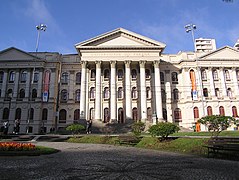 The Universidade Federal do Paraná is the oldest Brazilian university.
 -


References[change | change source]
- ↑ "Contas Regionais: PIB do Piauí cresce 8,8%, maior alta de 2008". www.ibge.gov.br (in Portuguese). Archived from the original on 2010-11-21.
- ↑ "Cresce o número de turistas estrangeiros em Foz do Iguaçu" (in Portuguese). Ministério do Turismo. Retrieved 2010-01-21.
- ↑ "Brazil State High Points". Peakbagger.com. Retrieved 22 July 2017.
- ↑ 4.0 4.1 4.2 "Estimativas da População Residente no Brasil e Unidades da Federaçã com Data de Referencia en 1o de julho de 2016" (PDF) (in Portuguese). Instituto Brasileiro de Geografia e Estatística (IBGE). Retrieved 22 July 2017.
- ↑ "Área Territorial Brasileira" (in Portuguese). Instituto Brasileiro de Geografia e Estatística (IBGE). Retrieved 20 January 2017.
- ↑ Pope, Gregory T. (December 1995), "The seven wonders of the modern world", Popular Mechanics, pp. 48–56
- ↑ 7.0 7.1 "Planejamento Urbano, Lazer e Turismo: Os Parques Públicos em Curitiba – PR" (in Portuguese). Renata M. Ribeiro/ Marco Aurélio T. Silveira. Archived from the original on 2018-06-24. Retrieved 2010-09-26.
- ↑ "PNAD" (PDF) (in Portuguese). 2005. Retrieved 2007-08-14.
- ↑ "Curitiba é eleita como Melhor Destino Cultural e Melhor Custo-Benefício para Turismo da Região Sul" (in Portuguese). ParanáShop. Archived from the original on 2012-04-22. Retrieved 2007-12-25.
- ↑ "Melhores do Brasil" (in Portuguese). O Melhor de Viagem 2007. Archived from the original on 2008-04-07. Retrieved 2008-03-04.