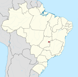
Brazilian Federal District
Federal District
Distrito Federal | |
|---|---|
| Motto(s): VENTVRIS VENTIS "To the coming winds" | |
 Location of Federal District in Brazil | |
| Coordinates: 15°47′42″S 47°45′28″W / 15.79500°S 47.75778°W | |
| Country | Brazil |
| Seat of government | Brasília |
| Government | |
| • Governor | Rodrigo Rollemberg (PSB) |
| • Vice Governor | Renato Santana (PSD) |
| • Senators | Cristovam Buarque (PPS) José Reguffe (I) Hélio José (PROS) |
| Area | |
| • Total | 5,802 km2 (2,240 sq mi) |
| • Rank | 27th |
| Population (February 2017)[1] | |
| • Total | 3,013,144 |
| • Rank | 20th |
| • Density | 520/km2 (1,300/sq mi) |
| • Rank | 1st |
| Demonym | Brasiliense |
| GDP | |
| • Year | 2015 estimate |
| • Total | US$116 billions(PPP) US$65 billions (8th) |
| • Per capita | US$38.549 (PPP)[2] US$21,779 (1st) |
| HDI | |
| • Year | 2014 |
| • Category | 0.839 [3] – very high (1st) |
| Time zone | UTC−03:00 (BRT) |
| • Summer (DST) | UTC−02:00 (BRST) |
| Postal code | 70000-000 to 73690-000 |
| ISO 3166 code | BR-DF |
| Website | df.gov.br |
The Federal District (Portuguese: Distrito Federal [d͡ʒisˈtɾitu fedeˈɾaw] (![]() listen)) is a part of Brazil, which is used to shelter Brasília, the federal capital. It is in the centre of the country.
listen)) is a part of Brazil, which is used to shelter Brasília, the federal capital. It is in the centre of the country.
History[change | change source]
The capital of Brazil was transferred from Rio de Janeiro to Brasília on 21 April 1960 and its new territory, split off from state of Goiás on the border with the state of Minas Gerais, became the current Federal District. After the transfer the old Federal District, containing the city of Rio de Janeiro, became the state of Guanabara. This state existed from 1960 until 1975, when it merged with the state of Rio de Janeiro. With the merger the capital of the state of Rio de Janeiro was transferred back from Niterói to Rio de Janeiro itself (as it had been until 1834 when the empire created the Neutral Municipality).
Originally, most of the people were local workers (called "Candangos"), who built the capital, and federal government workers who were sent to the new capital, Brasília. The capital is a planned city. It had areas built for homes, business, schools and other uses. Originally built for up to one million people, the city now has many more than one million people. Because of how the city was built, it has been hard for the city to grow. This has caused many people to live in cities around Brasília. A large percentage of the people of the Federal District live outside the city now.
Flag[change | change source]
The white color is for peace. The green and yellow colors in the middle refer to the national colors of Brazil. The four yellow arrows are for the native people of Brazil. The arrows pointing into the four cardinal directions of the compass stands for the power moving out from the center. The yellow arrows also form a cross. This is a symbol of the Southern Cross carried by the explorer Pedro Álvares Cabral.
The flag was created by the poet Guilherme de Almeida, and was adopted by decree no. 1090 on August 25, 1969.
References[change | change source]
- ↑ "IBGE - Projeção da população". www.IBGE.gov.br. Retrieved 3 August 2017.
- ↑ Pontes, Helena Maria Mattos. "IBGE - Agência de Notícias". Agência de Notícias - Ibge. Retrieved 18 March 2018.
- ↑ "Archived copy" (PDF). Archived from the original (PDF) on 2017-03-07. Retrieved 2018-05-10.
{{cite web}}: CS1 maint: archived copy as title (link)
Other websites[change | change source]
- Official homepage Archived 2014-06-25 at the Wayback Machine (in Portuguese)
- Informative Federal District page, with aeroplane view Archived 2006-06-30 at the Wayback Machine (in Portuguese)
- Feature article on CityMayors.com
- Distrito Federal at Google Maps
- Map of the Federal District Archived 2011-06-09 at the Wayback Machine
| States of Brazil | |
|---|---|
| Acre | Alagoas | Amapá | Amazonas | Bahia | Ceará | Espírito Santo | Goiás | Maranhão | Mato Grosso | Mato Grosso do Sul | Minas Gerais | Pará | Paraíba | Paraná | Pernambuco | Piauí | Rio de Janeiro | Rio Grande do Norte | Rio Grande do Sul | Rondônia | Roraima | Santa Catarina | São Paulo | Sergipe | Tocantins | |
| Federal district: Distrito Federal | |


