Misiones Province
Misiones | |
|---|---|
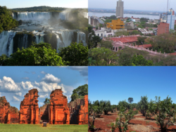
 Clockwise from top: Iguazú Falls (Iguazú National Park), Posadas, Guaraní Jesuit Mission of San Ignacio Miní, Yerba Mate plantation. | |
 Location of Misiones within Argentina | |
| Coordinates: 26°55′S 54°31′W / 26.92°S 54.52°W | |
| Country | Argentina |
| Capital | Posadas |
| Departments | 17 |
| Municipalities | 78 |
| Government | |
| • Governor | Oscar Herrera Ahuad |
| • Deputies | 7 |
| • Senators | 3 |
| Area | |
| • Total | 29.801 km2 (11.506 sq mi) |
| Population (2010[1]) | |
| • Total | 1.097.829 (Ranked 10th) |
| • Density | 36.8/km2 (95/sq mi) |
| Demonym | misionero |
| Time zone | UTC−3 (ART) |
| ISO 3166 code | AR-N |
| Website | www |
Misiones is one of the provinces of Argentina. It is in the northeastern corner of the country. Paraguay is to the northwest. Brazil is to the north, east and south. There are 965,522 people living in Misiones. Iguazú National Park is here.
The province first had Guarani people.
Misiones makes the most yerba mate in all of Argentina. Light manufacturing and tourism also help the economy.
References[change | change source]
| Provinces of Argentina | |
|---|---|
| Buenos Aires | Buenos Aires Province | Catamarca | Chaco | Chubut | Córdoba | Corrientes | Entre Ríos | Formosa | Jujuy | La Pampa | La Rioja | Mendoza | Misiones | Neuquen | Río Negro | Salta | San Juan | San Luis | Santa Cruz | Santa Fe | Santiago del Estero | Tierra del Fuego, Antarctica, and South Atlantic Islands | Tucumán | |


