
Flossenbürg, Bavaria
Flossenbürg | |
|---|---|
 | |
 Coat of arms | |
Location of Flossenbürg within Neustadt a.d.Waldnaab district  | |
 Flossenbürg  Flossenbürg | |
| Coordinates: 49°44′9″N 12°20′55″E / 49.73583°N 12.34861°E | |
| Country | Germany |
| State | Bavaria |
| Admin. region | Upper Palatinate |
| District | Neustadt a.d.Waldnaab |
| Subdivisions | 16 Ortsteile |
| Government | |
| • Mayor (2020–26) | Thomas Meiler[1] (CSU) |
| Area | |
| • Total | 23.26 km2 (8.98 sq mi) |
| Elevation | 644 m (2,113 ft) |
| Population (2022-12-31)[2] | |
| • Total | 1,460 |
| • Density | 63/km2 (160/sq mi) |
| Time zone | UTC+01:00 (CET) |
| • Summer (DST) | UTC+02:00 (CEST) |
| Postal codes | 92696 |
| Dialling codes | 09603, 09636 |
| Vehicle registration | NEW |
| Website | www |
Flossenbürg (Northern Bavarian: Flossenbirch) is a municipality in Neustadt an der Waldnaab in Bavaria in Germany. The state-approved leisure area is in the Bavarian Forest and borders Bohemia (the Czech Republic) in the east. During World War II, the Flossenbürg concentration camp was here.
-
 Fortified house, the topmost and oldest part of Flossenbürg Castle.
 -
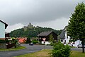 Flossenbürg seen from north - west. In the background there is the castle.


References[change | change source]
- ↑ Liste der ersten Bürgermeister/Oberbürgermeister in kreisangehörigen Gemeinden, Bayerisches Landesamt für Statistik, 15 July 2021.
- ↑ Genesis Online-Datenbank des Bayerischen Landesamtes für Statistik Tabelle 12411-003r Fortschreibung des Bevölkerungsstandes: Gemeinden, Stichtag (Einwohnerzahlen auf Grundlage des Zensus 2011)

| International | |
|---|---|
| National | |
| Geographic | |