Fort Sumner, New Mexico
Appearance
Fort Sumner, New Mexico | |
|---|---|
 Downtown Fort Sumner in 2003 | |
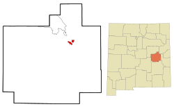
 Location of Fort Sumner, New Mexico | |
| Coordinates: 34°28′18″N 104°14′43″W / 34.47167°N 104.24528°W | |
| Country | United States |
| State | New Mexico |
| County | De Baca |
| Area | |
| • Total | 3.35 sq mi (8.66 km2) |
| • Land | 3.31 sq mi (8.58 km2) |
| • Water | 0.03 sq mi (0.08 km2) |
| Elevation | 4,032 ft (1,229 m) |
| Population | |
| • Total | 889 |
| • Density | 268.17/sq mi (103.56/km2) |
| Time zone | UTC−7 (Mountain (MST)) |
| • Summer (DST) | UTC−6 (MDT) |
| ZIP code | 88119 |
| Area code | 575 |
| FIPS code | 35-27340 |
| GNIS feature ID | 923600 |
Fort Sumner is a village in the state of New Mexico in the United States. It is the county seat of De Baca County.
References
[change | change source]- ↑ "ArcGIS REST Services Directory". United States Census Bureau. Retrieved October 12, 2022.
- ↑ "Profile of General Population and Housing Characteristics: 2020 Demographic Profile Data (DP-1): Fort Sumner village, New Mexico". United States Census Bureau. Retrieved March 14, 2024.

