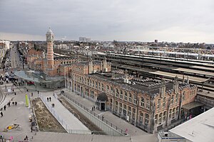
Gent-Sint-Pieters railway station
| Railway Station | |
 Gent-Sint-Pieters railway station | |
| General information | |
| Location | Koningin Maria Hendrikaplein, 9000 Ghent Belgium |
| Coordinates | 51°02′07″N 3°42′35″E / 51.03528°N 3.70972°E |
| Owned by | NMBS/SNCB |
| Operated by | NMBS/SNCB |
| Line(s) | 50, 50A, 58, 59, 75 |
| Platforms | 12 |
| Tracks | 12 |
| Construction | |
| Bicycle facilities | 17,000 (under construction) |
| Other information | |
| Station code | GSTP |
| History | |
| Opened | 1912 |
| Rebuilt | 2010–present |
| Passengers | |
| Passengers (2018) | 16.7 million |
 | |
| Location | |
Gent-Sint-Pieters railway station (Dutch: Station Gent-Sint-Pieters, French: Gare de Gand-Saint-Pierre){{ Officially Gent-Sint-Pieters (Dutch: Gent-Sint-Pieters, French: Gand-Saint-Pierre)}} is the main railway station in Ghent, East Flanders, Belgium, and the fourth-busiest in Belgium and busiest in Flanders, with 17.65 million passengers a year.[1] The station is operated by the National Railway Company of Belgium (NMBS/SNCB).[2]
References[change | change source]
- ↑ SNCB Mobility. "Reizigerstellingen 2009" (in Dutch). Archived from the original on 2020-11-03. Retrieved 2024-03-10. - Détail du calcul : (261xNbre voyageur jours de semaine) + (52xNbre Samedi) + (52xNbre Dimanche)
- ↑ "GENT-SINT-PIETERS". www.belgianrail.be. Retrieved 2023-11-06.


