Höchstädt an der Donau
Höchstädt an der Donau | |
|---|---|
 Höchstädt Castle | |
| Coordinates: 48°36′N 10°33′E / 48.600°N 10.550°E | |
| Country | Germany |
| State | Bavaria |
| Admin. region | Schwaben |
| District | Dillingen |
| Government | |
| • Mayor (2018–24) | Gerrit Maneth[1] (FW) |
| Area | |
| • Total | 37.45 km2 (14.46 sq mi) |
| Elevation | 416 m (1,365 ft) |
| Population (2022-12-31)[2] | |
| • Total | 7,014 |
| • Density | 190/km2 (490/sq mi) |
| Time zone | UTC+01:00 (CET) |
| • Summer (DST) | UTC+02:00 (CEST) |
| Postal codes | 89420 |
| Dialling codes | 09074 |
| Vehicle registration | DLG |
| Website | www.hoechstaedt.de |

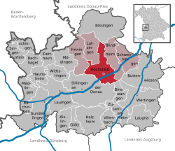
Höchstädt an der Donau (Swabian German: Hechstädt) is a town in the district of Dillingen, Bavaria, Germany. It is near the banks of the Danube. It contains of the following suburbs: Höchstädt an der Donau, Deisenhofen, Oberglauheim, Schwennenbach and Sonderheim. The town is the seat of the municipal association Höchstädt an der Donau, which includes the towns Blindheim, Finningen, Lutzingen and Schwenningen.
References[change | change source]
- ↑ Liste der ersten Bürgermeister/Oberbürgermeister in kreisangehörigen Gemeinden, Bayerisches Landesamt für Statistik, accessed 19 July 2021.
- ↑ Genesis Online-Datenbank des Bayerischen Landesamtes für Statistik Tabelle 12411-003r Fortschreibung des Bevölkerungsstandes: Gemeinden, Stichtag (Einwohnerzahlen auf Grundlage des Zensus 2011)


