Iviers
- Asturianu
- 閩南語 / Bân-lâm-gú
- Català
- Cebuano
- Deutsch
- English
- Español
- Euskara
- Français
- Հայերեն
- Bahasa Indonesia
- Italiano
- Kurdî
- Latina
- Lombard
- Magyar
- Malagasy
- Bahasa Melayu
- Nederlands
- Нохчийн
- Occitan
- Oʻzbekcha / ўзбекча
- Piemontèis
- Polski
- Português
- Română
- Русский
- Scots
- Shqip
- Slovenčina
- Svenska
- Татарча / tatarça
- Basa Ugi
- Українська
- Vèneto
- Tiếng Việt
- Winaray
- 粵語
- Zazaki
- Zeêuws
- 中文
From Simple English Wikipedia, the free encyclopedia
Iviers | |
|---|---|
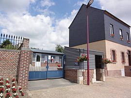
 The town hall of Iviers | |
| Coordinates: 49°47′04″N 4°08′37″E / 49.7844°N 4.1436°E / 49.7844; 4.1436 | |
| Country | France |
| Region | Hauts-de-France |
| Department | Aisne |
| Arrondissement | Vervins |
| Canton | Aubenton |
| Intercommunality | Pays des Trois Rivières |
| Government | |
| • Mayor (2008–2014) | Gérard Manteau |
| Area 1 | 7.45 km2 (2.88 sq mi) |
| Population (2008) | 183 |
| • Density | 25/km2 (64/sq mi) |
| Time zone | UTC+01:00 (CET) |
| • Summer (DST) | UTC+02:00 (CEST) |
| INSEE/Postal code | 02388 /02360 |
| Elevation | 172–250 m (564–820 ft) (avg. 210 m or 690 ft) |
| 1 French Land Register data, which excludes lakes, ponds, glaciers > 1 km2 (0.386 sq mi or 247 acres) and river estuaries. | |
Iviers is a commune. It is found in the region Picardie in the Aisne department in the north of France.[1]
References[change | change source]
- ↑ "Populations légales 2016 − Commune d'Iviers (02388) | Insee". www.insee.fr. Retrieved 2019-08-03.
Other websites[change | change source]
![]() Media related to Iviers at Wikimedia Commons
Media related to Iviers at Wikimedia Commons
Retrieved from "https://simple.wikipedia.org/w/index.php?title=Iviers&oldid=6650580"


