
Jennette, Arkansas
Jennette, Arkansas | |
|---|---|
 Location of Jennette in Crittenden County and St. Francis County, Arkansas. | |
| Coordinates: 35°9′59″N 90°24′42″W / 35.16639°N 90.41167°W | |
| Country | United States |
| State | Arkansas |
| Counties | Crittenden, St. Francis |
| Area | |
| • Total | 2.27 sq mi (5.88 km2) |
| • Land | 2.27 sq mi (5.87 km2) |
| • Water | 0.01 sq mi (0.01 km2) |
| Elevation | 207 ft (63 m) |
| Population (2020) | |
| • Total | 118 |
| • Density | 52.10/sq mi (20.11/km2) |
| Time zone | UTC−06:00 (Central (CST)) |
| • Summer (DST) | UTC−05:00 (CDT) |
| FIPS code | 05-35040 |
| GNIS feature ID | 1669458[2] |
Jennette is a town in the US state of Arkansas.
References[change | change source]
- ↑ "2020 U.S. Gazetteer Files". United States Census Bureau. Retrieved October 29, 2021.
- ↑ 2.0 2.1 U.S. Geological Survey Geographic Names Information System: Jennette, Arkansas
Municipalities and communities of Crittenden County, Arkansas, United States | ||
|---|---|---|
| Cities | 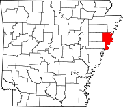 | |
| Towns | ||
| Unincorporated communities | ||
Municipalities and communities of St. Francis County, Arkansas, United States | ||
|---|---|---|
| Cities |  | |
| Towns | ||
| CDP | ||
| Other unincorporated communities | ||
| Footnotes | ‡This populated place also has portions in an adjacent county or counties | |