Klamath Falls, Oregon
Klamath Falls, Oregon | |
|---|---|
 Upper Klamath Falls | |
| Nickname: Oregon's City of Sunshine | |
| Motto: "Working For You" | |
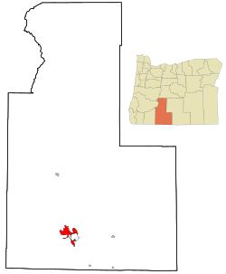
 Location in Oregon | |
| Coordinates: 42°13′30″N 121°46′54″W / 42.22500°N 121.78167°W | |
| Country | United States |
| State | Oregon |
| County | Klamath |
| Incorporated | 1905 |
| Area | |
| • Total | 20.96 sq mi (54.27 km2) |
| • Land | 20.08 sq mi (52.01 km2) |
| • Water | 0.88 sq mi (2.27 km2) |
| Elevation | 4,094 ft (1,248 m) |
| Population | |
| • Total | 21,813 |
| • Density | 1,086.30/sq mi (419.43/km2) |
| Time zone | UTC−8 (Pacific) |
| • Summer (DST) | UTC−7 (Pacific) |
| ZIP codes | 97601, 97603 |
| Area code | 541 |
| FIPS code | 41-39700[4] |
| GNIS feature ID | 2411554[2] |
| Website | City Website |
Klamath Falls (/ˈklæməθ/ KLAM-əth) (Klamath: ʔiWLaLLoonʔa[5]) is a city in Klamath County, Oregon, United States. It was first called Linkville when George Nurse founded the town in 1867. This name came from the Link River, because the city sat on its falls. No falls exist there currently. The name was changed to Klamath Falls in 1892. As of the 2020 census, 21,813 people lived there.[3]
History
[change | change source]The Klamath and Modoc Indians were the first people to live in the area. The Klamath name for this place was Yulalona or Iwauna. Their name for the falls was Tiwishkeni, or "where the falling waters rush".[6]
The Klamath Reclamation Project began in 1906. The aim of this project was to drain marshland and move water to allow agriculture. When the main "A" Canal was built, water was first available on May 22, 1907. Veterans of World War I and World War II were allowed to live there.[7]
Geography
[change | change source]The United States Census Bureau says that the city has a total area of 21.0 square miles (54.4 km2). 20.1 square miles (52.1 km2) of this is land and 0.8 square miles (2.1 km2) (4.0%) is water.[8] The elevation is 4,099 feet (1,249 m).
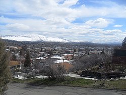
Klamath Falls has a high desert landscape. The older part of the city is above natural geothermal springs. These have been used to heat houses and streets, mostly in the downtown area.[9]
Sister city
[change | change source]Klamath Falls has one sister city:[10]
Related pages
[change | change source]References
[change | change source]- ↑ "ArcGIS REST Services Directory". United States Census Bureau. Retrieved October 12, 2022.
- ↑ 2.0 2.1 U.S. Geological Survey Geographic Names Information System: Klamath Falls, Oregon
- ↑ 3.0 3.1 "QuickFacts: Klamath Falls city, Oregon". United States Census Bureau. Retrieved February 22, 2024.
- ↑ "U.S. Census website". United States Census Bureau. Retrieved January 31, 2008.
- ↑ "Vocabulary". Klamath Tribes Language Project. The Klamath Tribes. Archived from the original on 2013-08-20. Retrieved 2012-08-30.
- ↑ "Name of Tiwishkeni". Archived from the original on 2009-03-09. Retrieved 2012-03-18.
- ↑ "Oregon History Project". Ohs.org. 1946-12-18. Retrieved 2010-07-08.
- ↑ "2020 U.S. Gazetteer Files". United States Census Bureau. Retrieved February 22, 2024.
- ↑ "US town uses geothermal energy to stay warm". AP. 2010-03-22. Archived from the original on 2011-06-14. Retrieved 8 July 2010.
- ↑ "Oranjestad, Aruba". 20 January 2012.
Other websites
[change | change source]- Entry for Klamath Falls in the Oregon Blue Book.


