Löbau-Zittau
Appearance
(Redirected from Löbau-Zittau Rural District)
Löbau-Zittau | |
|---|---|
 | |
| Coordinates: 50°54′N 14°48′E / 50.900°N 14.800°E | |
| Country | Germany |
| State | Saxony |
| Adm. region | Dresden |
| Disbanded | 2008 |
| Capital | Zittau |
| Area | |
| • Total | 698.51 km2 (269.70 sq mi) |
| Population (2001) | |
| • Total | 152,304 |
| • Density | 220/km2 (560/sq mi) |
| Time zone | UTC+01:00 (CET) |
| • Summer (DST) | UTC+02:00 (CEST) |
| Vehicle registration | ZI |
| Website | http://www.lra-loebau-zittau.de |
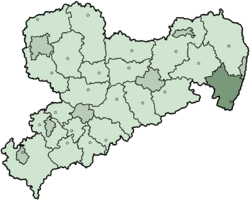
Löbau-Zittau (Sorbian languages: Wokrjes Lubij-Žitawa) was a Kreis (district) in the east of the Free State of Saxony, Germany. It ended in 2008. It was on the borders of Germany and Poland (to the east) and the Czech Republic (to the south).
History
[change | change source]The district was formed in 1994 by merging the two previous districts Löbau and Zittau. The district will change again in 2008, when the independent city (Kreisfreiestadt) of Görlitz is merged with the district.
Other websites
[change | change source]- Official website Archived 2007-02-05 at the Wayback Machine (in German)

