Le Palais
Le Palais
Porzh-Lae | |
|---|---|
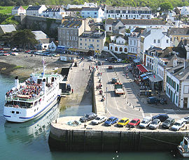
 Ferry in the harbour | |
| Coordinates: 47°20′50″N 3°09′15″W / 47.3472°N 3.1542°W | |
| Country | France |
| Region | Brittany |
| Department | Morbihan |
| Arrondissement | Lorient |
| Canton | Quiberon |
| Intercommunality | Belle-Île-en-Mer |
| Government | |
| • Mayor (2020–2026) | Tibault Grollemund |
| Area 1 | 17.43 km2 (6.73 sq mi) |
| Population (Jan. 2019)[1] | 2,544 |
| • Density | 150/km2 (380/sq mi) |
| Time zone | UTC+01:00 (CET) |
| • Summer (DST) | UTC+02:00 (CEST) |
| INSEE/Postal code | 56152 /56360 |
| Elevation | 0–58 m (0–190 ft) |
| 1 French Land Register data, which excludes lakes, ponds, glaciers > 1 km2 (0.386 sq mi or 247 acres) and river estuaries. | |
Le Palais (Breton: Porzh-Lae) is a commune. It is in Brittany in the Morbihan department in northwest France. It is one of the four communes on the island of Belle Île.
References[change | change source]
- ↑ "Populations légales 2019". The National Institute of Statistics and Economic Studies. 29 December 2021.


