
Marburg
Marburg | |
|---|---|
 Marburg: the castle, upper town, and St Elizabeth's church | |
 Coat of arms | |
Location of Marburg within Marburg-Biedenkopf district  | |
 Marburg  Marburg | |
| Coordinates: 50°48′36″N 08°46′15″E / 50.81000°N 8.77083°E | |
| Country | Germany |
| State | Hesse |
| District | Marburg-Biedenkopf |
| Government | |
| • Lord mayor | Dr. Thomas Spies (SPD) |
| Area | |
| • Total | 124.5 km2 (48.1 sq mi) |
| Highest elevation | 412 m (1,352 ft) |
| Lowest elevation | 173 m (568 ft) |
| Population (2022-12-31)[1] | |
| • Total | 77,845 |
| • Density | 630/km2 (1,600/sq mi) |
| Time zone | UTC+01:00 (CET) |
| • Summer (DST) | UTC+02:00 (CEST) |
| Postal codes | 35001-35043 |
| Dialling codes | 06421 |
| Vehicle registration | MR |
| Website | Stadt Marburg |
Marburg is a city in Hesse, Germany, on the Lahn river. It is the main town of the Marburg-Biedenkopf Rural District. It has about 80,000 inhabitants and a small, but well-known university, the Philipps-University.
The upper part of Old town, near the castle and above the former village 'Weidenhausen' at river Lahn and a bridge is called 'Oberstadt' (upper town).
There are timber framing houses, similar to some houses in Alsfeld (Vogelsbergkreis).
Cycling trail Lahntalradweg along the river connects Marburg with Gießen in the South.[2]
-
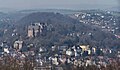 Marburg with its castle and a hill
 -
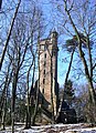 A special tower near Marburg
 -
 The town hall in Marburg, at square 'market place' of 'Oberstadt'
 -
 The Neustadt in the centre of Marburg
 -
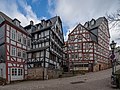 timber framing houses near of town hall


Geography[change | change source]
The Lahn valley is surrounded by hill chains called Lahnberge and Marburger Rücken in the Central Uplands (Mittelgebirge), part of West Hesse Highlands. The city districts Cyriaxweimar, Elnhausen, Michelbach and Schröck are on the other side of these two hill chains.

References[change | change source]
- ↑ "Bevölkerung in Hessen am 31.12.2022 nach Gemeinden" (XLS) (in German). Hessisches Statistisches Landesamt. June 2023.
- ↑ Lahntalradweg - Hessischer Radfernweg, hessen.de
Other websites[change | change source]
![]() Media related to Marburg at Wikimedia Commons
Media related to Marburg at Wikimedia Commons
| Urban districts in Darmstadt Regierungsbezirk | |
|---|---|
| Rural districts in Darmstadt Regierungsbezirk | |
| Towns with special status in Gießen Regierungsbezirk | |
| Rural districts in Gießen Regierungsbezirk | |
| Urban districts in Regierungsbezirk Kassel | |
| Towns with special status in Regierungsbezirk Kassel | |
| Rural districts in Regierungsbezirk Kassel | |