Montbard
Montbard | |
|---|---|
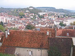
 Montbard and the Brenne river. | |
| Coordinates: 47°37′25″N 4°20′16″E / 47.6236°N 4.3378°E | |
| Country | France |
| Region | Bourgogne-Franche-Comté |
| Department | Côte-d'Or |
| Arrondissement | Montbard |
| Canton | Montbard |
| Intercommunality | Montbardois |
| Government | |
| • Mayor (2014–2020) | Laurence Porte[1] |
| Area 1 | 46.37 km2 (17.90 sq mi) |
| Population (2014) | 5,350 |
| • Density | 120/km2 (300/sq mi) |
| Time zone | UTC+01:00 (CET) |
| • Summer (DST) | UTC+02:00 (CEST) |
| INSEE/Postal code | 21425 /21500 |
| Elevation | 202–366 m (663–1,201 ft) (avg. 284 m or 932 ft) |
| Website | www.montbard.com |
| 1 French Land Register data, which excludes lakes, ponds, glaciers > 1 km2 (0.386 sq mi or 247 acres) and river estuaries. | |
Montbard is a commune and subprefecture of the Côte-d'Or department in the Bourgogne-Franche-Comté region in eastern France. It is also the capital of the arrondissement of Montbard and of the canton of Montbard.
Geography
[change | change source]The commune of Montbard has an area of 46.4 km2 (17.9 sq mi),[2] and its average altitude is 284 m (932 ft); at the city hall, the altitude is 211 m (692 ft).[3]
| Dijon | Paris | Reims | Strasbourg | Lyon | Marseille | Nice |
|---|---|---|---|---|---|---|
| 74 km (46 mi) | 267 km (166 mi) | 230 km (140 mi) | 433 km (269 mi) | 248 km (154 mi) | 559 km (347 mi) | 714 km (444 mi) |

|
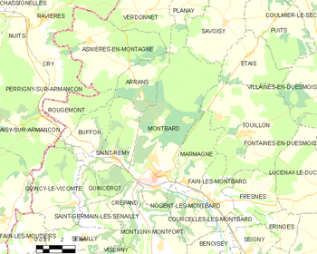
The commune of Montbard is surrounded by the communes:
The city of Montbard is to the northwest of the city of Dijon, capital of the department, and in the valley of the Brenne river.
Climate
[change | change source]The climate of Montbard is Marine West Coast Climate (Köppen climate classification: Cfb), with mild winters and warm summers.
Population
[change | change source]The inhabitants of Montbard are known, in French, as Montbardois (women: Montbardoises).[4]
With a population of 5,350,[5] Montbard has a population density of 115 inhabitants/km2.
Evolution of the population in Montbard

Administration
[change | change source]Montbard is a subprefecture of the Côte-d'Or department since 1926. It is also the capital of the arrondissement of Montbard and the administrative centre (French: chef-lieu) of the canton of Montbard formed by 57 communes, with 18,764 inhabitants (2014).[6]
Twin towns
[change | change source]Gallery
[change | change source]Related pages
[change | change source]References
[change | change source]- ↑ "Conseil municipal" (in French). Mairie de Montbard. Retrieved 7 June 2017.
- ↑ "Commune de Montbard (21425)". Comparateur de territoire (in French). Institut national de la statistique et des études économiques - INSEE. Retrieved 7 June 2017.
- ↑ "City of Montbard". Map-France.com. Retrieved 7 June 2017.
- ↑ "Côte-d'Or" (in French). habitants.fr. Retrieved 7 June 2017.
- ↑ "Régions, départements, arrondissements, cantons et communes" (PDF). Populations légales 2014 (in French). Institut national de la statistique et des études économiques - INSEE. Retrieved 7 June 2017.
- ↑ "Commune de Montbard (21425)". Géographie administrative et d’étude (in French). Institut national de la statistique et des études économiques - INSEE. Retrieved 7 June 2017.
- ↑ "Jumelages" (in French). Mairie de Montbard. Retrieved 7 June 2017.
Other websites
[change | change source]- Mairie de Montbard - Official site (in French)
- Departmental Council of Côte d'Or Archived 2018-06-10 at the Wayback Machine (in French)
- Prefecture official website Archived 2006-02-18 at the Wayback Machine (in French)
- Office de tourisme du Montbardois (in French)


