Nördlingen
Nördlingen | |
|---|---|
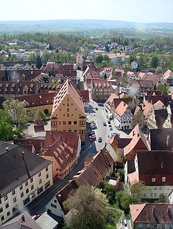
 Nördlingen, south view from the church tower Daniel | |
| Coordinates: 48°51′4″N 10°29′18″E / 48.85111°N 10.48833°E | |
| Country | Germany |
| State | Bavaria |
| Admin. region | Swabia |
| District | Donau-Ries |
| Government | |
| • Lord mayor | Hermann Faul (PWG) |
| Area | |
| • Total | 68.10 km2 (26.29 sq mi) |
| Elevation | 441 m (1,447 ft) |
| Population (2022-12-31)[1] | |
| • Total | 21,009 |
| • Density | 310/km2 (800/sq mi) |
| Time zone | UTC+01:00 (CET) |
| • Summer (DST) | UTC+02:00 (CEST) |
| Postal codes | 86720 |
| Dialling codes | 09081 |
| Vehicle registration | DON, NÖ |
| Website | www |
Nördlingen is a town in the district of Donau-Ries in Bavaria in Germany. The mayor is currently Hermann Faul. Two battles during the Thirty Years' War took place here. It is one of only three German towns to still have a complete city wall.

References[change | change source]
- ↑ Genesis Online-Datenbank des Bayerischen Landesamtes für Statistik Tabelle 12411-003r Fortschreibung des Bevölkerungsstandes: Gemeinden, Stichtag (Einwohnerzahlen auf Grundlage des Zensus 2011)


