Nangarhar Province
Nangarhar Province
ننگرهار | |
|---|---|
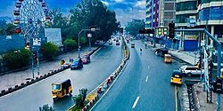
 Street in Jalalabad city | |
 Map of Afghanistan with Nangarhar highlighted | |
| Coordinates (Capital): 34°15′N 70°30′E / 34.25°N 70.50°E | |
| Country | |
| Capital | Jalalabad |
| Government | |
| • Governor | Hajji Gul Mohammad[1] |
| • Deputy Governor | Maulvi Niaz Mohammad Wahaj[2] |
| • Police Chief | Neda Mohammad |
| Area | |
| • Total | 7,727 km2 (2,983 sq mi) |
| Population (2021)[3] | |
| • Total | 1,735,531 |
| • Density | 220/km2 (580/sq mi) |
| Time zone | UTC+4:30 (Afghanistan Time) |
| ISO 3166 code | AF-NAN |
| Main languages | Pashto, Dari |
Nangarhar (Pashto: ننګرهار Nangarhār) is one of the 34 provinces of Afghanistan. It is in the east of the country. Jalalabad is the capital. There are 1,383,900 people in the province.[4]
Districts[change | change source]

Nangarhar province is divided into 22 districts, these are:
| District | Capital | Population[5] | Area[6] | Notes |
|---|---|---|---|---|
| Achin | 95,468 | |||
| Bati Kot | 71,308 | |||
| Bihsud | 118,934 | Created in 2005 within Jalalabad District | ||
| Chaparhar | 57,339 | |||
| Dara-I-Nur | 28,202 | |||
| Dih Bala | 33,294 | |||
| Dur Baba | 13,479 | |||
| Goshta | 31,130 | |||
| Hisarak | 28,376 | |||
| Jalalabad | 205,423 | Sub-divided in 2005 | ||
| Kama | 52,527 | |||
| Khogyani | 111,479 | |||
| Kot | 52,154 | Created in 2005 within Rodat District | ||
| Kuz Kunar | 42,823 | |||
| Lal Pur | 18,997 | |||
| Momand Dara | 42,103 | |||
| Nazyan | 16,328 | |||
| Pachir Aw Agam | 40,141 | |||
| Rodat | 63,357 | Sub-divided in 2005 | ||
| Sherzad | 63,232 | |||
| Shinwar | 64,872 | |||
| Surkh Rod | 91,548 |
References[change | change source]
- ↑ "Taliban appoint new leaders of two provinces in Eastern Afghanistan after deadly attacks". The Nation. 2021-09-21. Retrieved 2021-09-24.
- ↑ "ننګرهارکې پر خواوشاه دوه زره کورنیو نغدې او ژمنۍ مرستې وویشل شوې نور حال په راپور کښې". 20 December 2021.
- ↑ "Estimated Population of Afghanistan 2021-22" (PDF). National Statistic and Information Authority (NSIA). April 2021. Archived (PDF) from the original on June 29, 2021. Retrieved June 21, 2021.
{{cite web}}:|archive-date=/|archive-url=timestamp mismatch; June 24, 2021 suggested (help) - ↑ Afghanistan Statistical Yearbook 2010/11 Archived 2016-04-29 at the Wayback Machine (PDF), Central Statistics Office Afghanistan
- ↑ http://www.mrrd.gov.af/nabdp/Provincial%20Profiles/Nangarhar%20PDP%20Provincial%20profile.pdf Archived 2010-03-04 at the Wayback Machine MRRD Provincial profile for Nangarhar Province
- ↑ "FAO in Afghanistan - Food and Agriculture Organization of the United Nations". www.fao.org.
