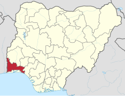
Ogun State
Ogun State | |
|---|---|
| Nickname: Gateway State | |
 Location of Ogun State in Nigeria | |
| Coordinates: 7°00′N 3°35′E / 7.000°N 3.583°E | |
| Country | |
| Date created | 3 February 1976 |
| Capital | Abeokuta |
| Government | |
| • Governor | Dapo Abiodun (APC) |
| • Deputy Governor | Yetunde Onanuga |
| • Senators |
|
| • Legislature | Ogun State House of Assembly |
| Area | |
| • Total | 16,980.55 km2 (6,556.23 sq mi) |
| • Rank | 24th of 36 |
| Population (2006 census) | |
| • Total | 3,751,140 |
| • Rank | 16 of 36 |
| • Density | 220/km2 (570/sq mi) |
| Demonym | Ogun |
| GDP | |
| • Year | 2007 |
| • Total | $10.47 billion[1] |
| • Per capita | $2,740[1] |
| Time zone | UTC+01 (WAT) |
| ISO 3166 code | NG-OG |
Ogun State is one of the 36 states in Nigeria. It is presently governed by Ibikunle Amosun and its capital is Abeokuta. The state consists of 20 local government areas including:[2]
- Abeokuta North
- Abeokuta South
- Ado-Odo/Ota
- Ewekoro
- Ifo
- Ijebu East
- Ijebu North
- Ijebu North East
- Ijebu Ode
- Ikenne
- Imeko Afon
- Ipokia
- Obafemi Owode
- Odogbolu
- Odeda
- Ogun Waterside
- Remo North
- Sagamu
(Shagamu) - Yewa North
(formerly Egbado North) - Yewa South
(formerly Egbado South)
References[change | change source]
- ↑ 1.0 1.1 "C-GIDD (Canback Global Income Distribution Database)". Canback Dangel. Retrieved 2008-08-20.
- ↑ S. O. Onakomaiya; Olabisi Onabanjo University. Centre for Sandwich Programmes (2000). Ogun State: local and regional perspectives. Centre for Sandwich Programmes (CESAP), Olabisi Onabanjo University. ISBN 978-978-35192-7-5.
