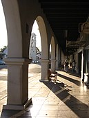
Ojai, California
Appearance
Ojai, California | |
|---|---|
|
Top to bottom, left to right: Ojai Valley Museum; U.S. Post Office; Ojai Arcade; aerial view of Ojai | |
 Location in Ventura County and the state of California | |
| Coordinates: 34°26′57″N 119°14′48″W / 34.44917°N 119.24667°W | |
| Country | United States |
| State | California |
| County | Ventura |
| Incorporated | August 5, 1921[1] |
| Named for | Chumash: 'Awha'y ("Moon")[2] |
| Government | |
| • Type | City Council—City Manager[3] |
| Area | |
| • Total | 4.37 sq mi (11.32 km2) |
| • Land | 4.36 sq mi (11.28 km2) |
| • Water | 0.01 sq mi (0.04 km2) 0.35% |
| Elevation | 745 ft (227 m) |
| Population | |
| • Total | 7,637 |
| • Density | 1,700/sq mi (670/km2) |
| Time zone | UTC−8 (Pacific) |
| • Summer (DST) | UTC−7 (PDT) |
| ZIP codes | 93023 & 93024 |
| Area code | 805 |
| FIPS code | 06-53476 |
| GNIS feature IDs | 1652763, 2411308 |
| Website | ojaicity |
Ojai (/ˈoʊhaɪ/ OH-hy) is a city in Ventura County in the U.S. state of California. It is northwest of Los Angeles and east of Santa Barbara. It is about 10 miles (16 km) long by 3 miles (5 km) wide, surrounded by hills and mountains. The population was 7,637 at the 2020 census.[6]
References
[change | change source]- ↑ "California Cities by Incorporation Date". California Association of Local Agency Formation Commissions. Archived from the original (Word) on November 3, 2014. Retrieved August 25, 2014.
- ↑ McCall, Lynne; Perry, Rosalind (2002). California's Chumash Indians : a project of the Santa Barbara Museum of Natural History Education Center (Revised ed.). San Luis Obispo, Calif: EZ Nature Books. ISBN 978-0936784151.
- ↑ "City Government". City of Ojai. Retrieved February 5, 2016.
- ↑ "2019 U.S. Gazetteer Files". United States Census Bureau. Retrieved July 1, 2020.
- ↑ "Ojai". Geographic Names Information System. United States Geological Survey.
- ↑ 6.0 6.1 "Ojai (city) QuickFacts". United States Census Bureau.


