Ordino
Ordino | |
|---|---|
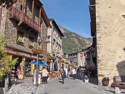
 An Ordino street and Casamanya mountain in the background | |
 Ordino parish, in red, in Andorra | |
| Coordinates: 42°33′18″N 1°31′59″E / 42.55500°N 1.53306°E | |
| Country | Andorra |
| Capital | Ordino |
| Villages | See list |
| Government | |
| • Mayor | J. Àngel Mortés Pons |
| Area | |
| • Total | 89.3 km2 (34.5 sq mi) |
| Elevation | 1,298 m (4,259 ft) |
| Population (2015)[2] | |
| • Total | 4,687 |
| • Density | 52/km2 (140/sq mi) |
| Demonym(s) | ordinenc, ordinenca |
| Time zone | UTC+1 (CET) |
| • Summer (DST) | UTC+2 (CEST) |
| Postal code | AD300 |
| ISO 3166 code | AD-05 |
| Website | Official website |
Ordino is one of the parishes of Andorra. It is the most northern parish of the country. Ordino is also the name of the main town of the parish. In the parish is the Parc Natural de Sorteny ("Sorteny Natural Park"), the largest nature area of Andorra.
History[change | change source]
Ordino is known for the several places where the iron ore was melted between the XVII and the XIX centuries. Besides being the industrial centre of Andorra, Ordino is considered the cultural centre of Andorra. Here Antoni Fiter i Rossell wrote the Manual Digest (1748), called the "Bible of Andorra," which tells the history, the government and the Andorran customs.[3]
Geography[change | change source]
The town of Ordino, the capital of the parish, is at 1,298 m (4,259 ft) above sea level. Most of the parish is in the valley of the Valira del Nord (or Valira d'Ordino) river, in the northwest of the country.
Ordino borders with France (Ariège department) to the north, with the Canillo parish to the east, the Encamp parish to the southeast and the La Massana parish to the south and the west.
Some of the highest mountains of Andorra are in the Ordino parish; some of them are:
- Pic de l'Estanyó, 2,915 m (9,564 ft) high
- Pic de la Serrera, 2,913 m (9,557 ft) high
- Pic de Font Blanca, 2,904 m (9,528 ft) high
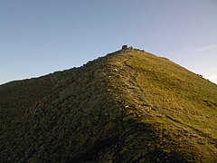
The town of Ordino is on the slopes of the Pic de Casamanya (or just Casamanya); it is 2,752 m (9,029 ft) high.
The main river in the parish is the Valira del Nord (or Valira d'Ordino) river, one of the two branches that form the Valira river.
Population[change | change source]
The parish had a population, in 2015 of 4,687 inhabitants,[2] for a population density of 52.5 persons/km².
Evolution of the population in Ordino[4]

| 1981 | 1986 | 1991 | 1996 | 2001 | 2006 | 2011 | 2015 |
|---|---|---|---|---|---|---|---|
| 761 | 1,096 | 1,582 | 1,931 | 2,366 | 3,467 | 4,322 | 4,687 |
Villages[change | change source]
There are other villages and hamlets besides the main town of Ordino in the parish:
| No. | Town | Population[5] (2015) |
Altitude[6] (m) |
Notes[6] |
|---|---|---|---|---|
| 1 | Ansalonga | 59 | 1,331 | It is on the left side of the Valira d'Ordino (or Valira del Nord) river. |
| 2 | Arans | 217 | 1,385 | It is on the right side of the Valira d'Ordino (or Valira del Nord) river. |
| 3 | El Serrat | 186 | 1,539 | It is main centre of the Ordino valley; here the iron ore was transformed in steel. |
| 4 | La Cortinada | 809 | 1,335 | It is along the Valira d'Ordino (or Valira del Nord) river. |
| 5 | Llorts | 162 | 1,413 | It is on the right side of the Valira d'Ordino river. |
| 6 | Ordino | 2,969 | 1,298 | The capital of the parish. |
| 7 | Segudet | 45 | 1,327 | Other name: Segudet. It is on the right side of the Cegudet river, a left tributary of the Valira d'Ordino river. |
| 8 | Sornàs | 240 | 1,514 | It is on the left side of the Valira d'Ordino (or Valira del Nord) river. |
Sites of interest[change | change source]
- Auditori Nacional d'Andorra ("National Auditorium of Andorra")
- Museu Postal d'Andorral ("Postal Museum of Andorra")
- Museu de la Miniatura ("Miniature Museum")
- Sant Martí de la Cortinada, a Romanesque church in La Cortinada, north of Ordino.
- Valle de Sorteny Natural Park, the largest natural park in Andorra.
- Vallnord, a ski/snowboard resort in the Pyrenees mountains; the Arcalís sector is in the Ordino parish.
Gallery[change | change source]
-
Sant Martí church, La Cortinada
-
The main street of Ordino
-
Ordino town centre
-
The summit of Casamanya
References[change | change source]
- ↑ "Composició del Comú". Comú de Sant Julià de Lòria (in Catalan). Retrieved 24 December 2016.
- ↑ 2.0 2.1 "Population by parish". Department d'Estadísticas - Govern d'Andorra. Archived from the original on 24 September 2015. Retrieved 24 December 2016.
- ↑ "Ordino routes". Hiking in Andorra. Archived from the original on 8 April 2017. Retrieved 24 December 2016.
- ↑ "Population by parish (1981-2016)". Department d'Estadísticas - Govern d'Andorra. Retrieved 21 August 2017.[permanent dead link]
- ↑ "Population by town". Department d'Estadísticas - Govern d'Andorra. Retrieved 23 December 2016.[permanent dead link]
- ↑ 6.0 6.1 "Enciclopèdia Catalana" (in Catalan). Grup Enciclopèdia Catalana. Retrieved 24 December 2016.


