
Röthenbach im Emmental
Röthenbach im Emmental | |
|---|---|
 Coat of arms | |
Location of Röthenbach im Emmental  | |
 Röthenbach im Emmental  Röthenbach im Emmental | |
| Coordinates: 46°51′N 7°44′E / 46.850°N 7.733°E | |
| Country | Switzerland |
| Canton | Bern |
| District | Emmental |
| Government | |
| • Mayor | Rudolf Megert |
| Area | |
| • Total | 36.8 km2 (14.2 sq mi) |
| Elevation | 824 m (2,703 ft) |
| Population (31 December 2018)[2] | |
| • Total | 1,169 |
| • Density | 32/km2 (82/sq mi) |
| Time zone | UTC+01:00 (Central European Time) |
| • Summer (DST) | UTC+02:00 (Central European Summer Time) |
| Postal code(s) | 3538 |
| SFOS number | 0904 |
| Localities | Dorf, Gauchern, Oberei, Würzbrunnen, Chüderhusi |
| Surrounded by | Bowil, Buchholterberg, Eggiwil, Eriz, Linden, Oberlangenegg, Schangnau, Signau, Wachseldorn |
| Website | www SFSO statistics |
Röthenbach im Emmental is a municipality in the administrative district Emmental in the canton of Bern in Switzerland.
Gallery[change | change source]
-
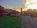 Röthenbach im Emmental
 -
 View from the Chuderhüsi observation tower above Würzbrunnen
 -
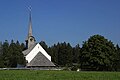 Church of Würzbrunnen
 -
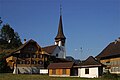 Church of Röthenbach im Emmental

.jpg)


References[change | change source]
- ↑ 1.0 1.1 "Arealstatistik Standard - Gemeinden nach 4 Hauptbereichen". Federal Statistical Office. Retrieved 13 January 2019.
- ↑ "Ständige Wohnbevölkerung nach Staatsangehörigkeitskategorie Geschlecht und Gemeinde; Provisorische Jahresergebnisse; 2018". Federal Statistical Office. 9 April 2019. Retrieved 11 April 2019.
Other websites[change | change source]
![]() Media related to Röthenbach im Emmental at Wikimedia Commons
Media related to Röthenbach im Emmental at Wikimedia Commons
- Official Website (in German)