Rancagua
Rancagua | |
|---|---|
| Ciudad de Rancagua | |
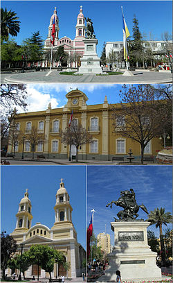
 Buildings surrounding Los Héroes Square, Rancagua. Top: Southern view of the plaza, Middle: Cachapoal Province Governorate, Bottom left. Sagrario Cathedral, Bottom right: Bernardo O'Higgins monument. | |
| Coordinates (city): 34°10′S 70°45′W / 34.167°S 70.750°W | |
| Country | |
| Region | |
| Province | Cachapoal Province |
| Foundation | October 5, 1743 |
| Government | |
| • Type | Municipality |
| • Alcalde | Eduardo Soto |
| Area | |
| • Total | 260.3 km2 (100.5 sq mi) |
| Elevation | 572 m (1,877 ft) |
| Population (2012 Census)[1] | |
| • Total | 232,211 |
| • Density | 890/km2 (2,300/sq mi) |
| • Urban | 206,971 |
| • Rural | 7,373 |
| Demonym | Ranquigüian |
| Sex | |
| • Men | 104,879 |
| • Women | 109,465 |
| Time zone | UTC−4 (CLT) |
| • Summer (DST) | UTC−3 (CLST) |
| Postal code | 2820000 |
| Area code | 56 (country) + 72 (city) |
| Police | Carabineros de Chile |
| International airports | Rancagua de la Independencia |
| Climate | Csb |
| Website | www |
Rancagua is a Chilean city with 214,344 people living there according to 2002 census.
History[change | change source]
Rancagua was founded by the Spanish soldier José Antonio Manso de Velasco on 1743.
Gallery[change | change source]
-
Rancagua Cathedral
-
Coat of Arms of Rancagua
-
Train Station
-
Cachapoal River
References[change | change source]
- ↑ 1.0 1.1 1.2 "National Statistics Institute" (in Spanish). Retrieved November 29, 2010.
Other websites[change | change source]
- Rancagua municipality (in Spanish)
Wikimedia Commons has media related to Rancagua.


