
Rubihorn
| Rubihorn | |
|---|---|
 The Rubihorn | |
| Highest point | |
| Elevation | 1,957 m (6,421 ft) |
| Prominence | 95 m (312 ft) |
| Isolation | 1 km (0.62 mi) |
| Coordinates | 47°25′28″N 10°18′55″E / 47.42444°N 10.31528°E |
| Geography | |
| Parent range | Allgäu Alps |

The Rubihorn is a mountain in Bavaria, Germany. It is 1,975 metres (6,480 ft) tall and is to the east of Oberstdorf. With the Nebelhorn it makes part of the Daumen Group. On 9 July 1987 there was a rockfall on the north face. The remains can still be seen today.
-
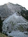 The rockfall on the Rubihorn
 -
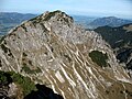 The Rubihorn from the south-west
 -
 The north face of the Rubihorn


