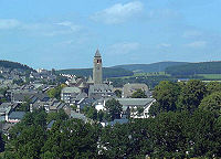
Schmallenberg
Schmallenberg | |
|---|---|
 Schmallenberg (Church St. Alexander) | |
| Coordinates: 51°08′56″N 8°17′04″E / 51.148983°N 8.284539°E | |
| Country | Germany |
| State | North Rhine-Westphalia |
| Admin. region | Arnsberg |
| District | Hochsauerland |
| Subdivisions | 83 |
| Government | |
| • Mayor | Burkhard König (CDU) |
| Area | |
| • Total | 303.00 km2 (116.99 sq mi) |
| Highest elevation | 831 m (2,726 ft) |
| Lowest elevation | 329 m (1,079 ft) |
| Population (2021-12-31)[1] | |
| • Total | 24,704 |
| • Density | 82/km2 (210/sq mi) |
| Time zone | UTC+01:00 (CET) |
| • Summer (DST) | UTC+02:00 (CEST) |
| Postal codes | 57392 |
| Dialling codes | 02971, 02972, 02974, 02975, 02977 |
| Vehicle registration | HSK |
| Website | www |
Schmallenberg is a town in the German state North Rhine-Westphalia. About 24,965 people live there.[2]
Geography[change | change source]
Schmallenberg is in the middle of the Sauerland (Rothaargebirge). It is about 25 kilometres (16 miles) south of Meschede, and 120 kilometres (75 miles) from Köln (Cologne).
Neighbouring communities[change | change source]
Lennestadt borders in the north on the communities of Bestwig and Meschede, in the east on Winterberg, in the south on Bad Berleburg, and in the west on the towns of Eslohe and Lennestadt.
Town twinning[change | change source]
Schmallenberg is twinned with
History[change | change source]
The Benedictine monastery began in 1072 near Schmallenberg on a site at the foot of the Wilzenberg mountain, by Saint Anno, Archbishop of Cologne.[3]
"Alexander de Smalenburg" is said to have given his name to the city of Schmallenberg. The origins of the narrow castle lie in a castle complex that belonged to Cologne, and in 1244 the curtain-walled settlement was officially elevated to city status by Konrad von Hochstaden, Archbishop of Cologne.
During the Middle Ages, textile and ironmongery trades were the main industries in Schmallenberg. Around 1350 there were about 800 living in the town. After an economically quiet period during the 16th century, the new iron hammer technology put the city back on the map. At that time, Schmallenberg’s ironmongery trade was considered the most important one in Westphalia.
In parts of the town like in Oberkirchen there were many witchcraft trials. In 1630 there were 7 processes, from April to June. During these, 58 people were convicted to burn at the stake, for alleged witchcraft. One of the victims was Christine Teipel, a 9-year-old child.
After a big fire in 1822, the town was rebuilt using a classical ground plan. This can still be seen today. Ten years before that, the city wall and gates had been torn down. Today, Schmallenberg’s typical features are its half-timbered houses with slated roofs and carved doors, small bays and gables as well as symmetric perrons.

Economy[change | change source]
Since the 19th century Schmallenberg was a "Sauerländer centre" of the textile industry (the largest company: FALKE-GROUP). This gave Schmallenberg the nickname "Strumpfstadt" ("socktown").[4] Since the development of the textile industry in Schmallenberg is declining dominated the economy many medium-sized enterprises and tourism. In 2002 there were 7924 on social insurance jobs.
Important Schmallenberger companies are:
- FALKE-GROUP (textile industry, 2006: 2,431 employees)
- Burgbad AG (bathroom furniture manufacturer with headquarters in Bad Fredeburg)
- Feldhaus (construction company)
Fraunhofer Society[change | change source]
The Fraunhofer Institute for Molecular Biology and Applied Ecology IME conducts research in the field of applied life sciences from a molecular level to entire ecosystems. The IME-Institute Archived 2011-07-19 at the Wayback Machine has about 140 employees working at the locations Schmallenberg and Aachen.
Sport[change | change source]

Hiking trails adding up to about 2,500 kilometers, leading through forests, across mountains and through valleys make Schmallenberg. The town at the upper course of the river Lenne has developed into one of Westphalia’s winter sports centers. 250 kilometers of cross-country ski tracks and 30 ski-lifts turn any kind of skiing.
Air transport[change | change source]
Schmallenberg's airport is Flugplatz Schmallenberg-Rennefeld (ICAO-Code: EDKR).
References[change | change source]
- ↑ "Bevölkerung der Gemeinden Nordrhein-Westfalens am 31. Dezember 2021" (in German). Landesbetrieb Information und Technik NRW. Retrieved 20 June 2022.
- ↑ "Bevölkerung der Gemeinden Nordrhein-Westfalens am 31. Dezember 2017", (in German). Landesbetrieb Information und Technik NRW. Retrieved, 2 March 2019.
- ↑ Stadt Schmallenberg: Beiträge zur Geschichte der Stadt Schmallenberg 1244–1969, Schmallenberg, 1969
- ↑ Verkehrsverein Schmallenberg: Holz- und Touristikzentrum [1] Archived 2013-11-01 at the Wayback Machine (in German)
Other websites[change | change source]
![]() Media related to Schmallenberg at Wikimedia Commons
Media related to Schmallenberg at Wikimedia Commons
- Flugplatz Schmallenberg-Rennefeld
- Official site (in German)
- Schmallenberger-Sauerland Archived 2009-10-04 at the Wayback Machine (in English)


