Sommerkahl
Appearance
Sommerkahl | |
|---|---|
 Sommerkahl with parish church, view from the east | |
| Coordinates: 50°04′N 9°16′E / 50.067°N 9.267°E | |
| Country | Germany |
| State | Bavaria |
| Admin. region | Lower Franconia |
| District | Aschaffenburg |
| Municipal assoc. | Schöllkrippen |
| Subdivisions | 2 Ortsteile |
| Government | |
| • Mayor (2020–26) | Albin Schäfer[1] (CSU) |
| Area | |
| • Total | 5.46 km2 (2.11 sq mi) |
| Elevation | 226 m (741 ft) |
| Population (2022-12-31)[2] | |
| • Total | 1,305 |
| • Density | 240/km2 (620/sq mi) |
| Time zone | UTC+01:00 (CET) |
| • Summer (DST) | UTC+02:00 (CEST) |
| Postal codes | 63825 |
| Dialling codes | 06024 |
| Vehicle registration | AB |
| Website | www.gemeinde-sommerkahl.de |
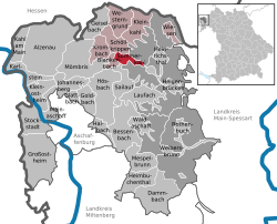
Sommerkahl is a community in the Aschaffenburg district in the Regierungsbezirk of Lower Franconia (Unterfranken) in Bavaria, Germany and a member of the Verwaltungsgemeinschaft (municipal association) of Schöllkrippen.
References
[change | change source]- ↑ Liste der ersten Bürgermeister/Oberbürgermeister in kreisangehörigen Gemeinden, Bayerisches Landesamt für Statistik, 15 July 2021.
- ↑ Genesis Online-Datenbank des Bayerischen Landesamtes für Statistik Tabelle 12411-003r Fortschreibung des Bevölkerungsstandes: Gemeinden, Stichtag (Einwohnerzahlen auf Grundlage des Zensus 2011) .
Other websites
[change | change source]Wikimedia Commons has media related to Sommerkahl.
- Wilhelmine coppermine Archived 2019-09-28 at the Wayback Machine (in German)


