
Sonthofen
Sonthofen | |
|---|---|
 Sonthofen | |
 Coat of arms | |
Location of Sonthofen within Oberallgäu district  | |
 Sonthofen  Sonthofen | |
| Coordinates: 47°30′57″N 10°16′52″E / 47.51583°N 10.28111°E | |
| Country | Germany |
| State | Bavaria |
| Admin. region | Schwaben |
| District | Oberallgäu |
| Government | |
| • Mayor | Christian Wilhelm |
| Area | |
| • Total | 20.982 km2 (8.101 sq mi) |
| Highest elevation | 1,100 m (3,600 ft) |
| Lowest elevation | 750 m (2,460 ft) |
| Population (2022-12-31)[1] | |
| • Total | 21,859 |
| • Density | 1,000/km2 (2,700/sq mi) |
| Time zone | UTC+01:00 (CET) |
| • Summer (DST) | UTC+02:00 (CEST) |
| Postal codes | 87527 |
| Dialling codes | 08321 |
| Vehicle registration | OA |
| Website | www.sonthofen.de |
Sonthofen is the most southern town of Germany. It is in the Oberallgäu region of the Bavarian Alps. Oberstdorf is 14 kilometres (8.7 mi) farther south but is not a town. In 2005, Sonthofen was awarded "Alpenstadt des Jahres" (Alpine city of the year).
In World War II Sonthofen was bombed twice. This was because Adolf Hitler had built the Ordensburg Sonthofen in Sonthofen. Young boys were trained there for Nazi Party organisations. Sonthofen was given town rights on 18 August 1963.
-
 Sonthofen
 -
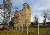 The Ordensburg
.JPG)

References
[change | change source]- ↑ Genesis Online-Datenbank des Bayerischen Landesamtes für Statistik Tabelle 12411-003r Fortschreibung des Bevölkerungsstandes: Gemeinden, Stichtag (Einwohnerzahlen auf Grundlage des Zensus 2011) .
| International | |
|---|---|
| National | |
| Geographic | |