
South Aral Sea
South Aral Sea was the name for the southern part of the Aral Sea. Because of diverting water for irrigation starting in the 1960s, the Aral Sea began to dry up. In the 1980s, a dam was built, splitting it into a small North Aral Sea, and the large southern part. In the 2000s, the souhern part split into a western and eastern half, but has mostly dried up. The desert that grew from it is called Aralkum today.
Current situation[change | change source]
The West Aral Sea is expected to stabilize at 2,700–3,500 km2 (1,040–1,350 sq mi), a mean depth of 14–15 m (46–49 ft), and a maximum depth of 37–40 m (121–131 ft), assuming groundwater discharge at the rate of 2 km3 (0.5 cu mi) per year.[1] The Eastern Sea dried up completely in the summer of 2009, apart from the small permanent Barsakelmes Lake (between the Northern and Western seas), but it received some water from snow melt in the spring of 2010. It is expected to alternate between complete desiccation in the summers and the occasional flood from the Amu Darya or spillover from the dam holding back the North Aral Sea, though a second dike, begun in 2010, may reduce the incidence of the latter.
-
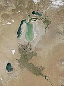 July 2002 – The sea's former bed is visible as lighter-colored areas, the lightest regions representing the most recent retreat.
 -
 November 2003 – Much of the Eastern Sea's water has evaporated, the jade green swirls representing sediment in the shallow water.
 -
 August 2009 – The Eastern Sea's mud flats have dried further, with only the faintest glimmer of water where it drains into the Western Sea. Barsakelmes Lake appears between the Northern and Western seas.
 -
 July 2010 – A closeup of the channel leading from the re-flooded Eastern Sea to the Western Sea. The white areas are the exposed salt flats of the new Aralkum desert.
 -
 August 2010 – Part of the Eastern Sea has been re-flooded by the Amu Darya from heavy snowmelt.
 -
 September 2011 – The Northern Sea and Eastern Sea lost water, while the Western Sea gained more water.
 -
 August 2014 – The Aral Sea completely loses its Eastern Lobe.


In 2015, the Western Sea was starting to split into two, as the channel that connects the central part of the sea and the small North-Eastern part was growing skinnier. (This can be seen on the 2014 picture.) Since 2018, the split has been complete.[2][3]
References[change | change source]
- ↑ Peter O. Zavialov, 2005, Physical oceanography of the dying Aral Sea, p 112
- ↑ https://www.weforum.org/agenda/2020/02/aral-sea-lake-water-nature-human-impact/ Satellite image of 2018
- ↑ https://eurasianet.org/northern-arals-promise-stunted-by-dam-height-international-disputes Satellite image of 2020