South Paris, Maine
South Paris, Maine | |
|---|---|
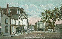
 Market Square in 1907 | |
| Coordinates: 44°13′18″N 70°30′53″W / 44.22167°N 70.51472°W | |
| Country | United States |
| State | Maine |
| County | Oxford |
| Area | |
| • Total | 3.95 sq mi (10.23 km2) |
| • Land | 3.88 sq mi (10.04 km2) |
| • Water | 0.07 sq mi (0.19 km2) |
| Elevation | 387 ft (118 m) |
| Population | |
| • Total | 2,183 |
| • Density | 563.21/sq mi (217.46/km2) |
| Demonym | South Parisian |
| Time zone | UTC-5 (Eastern (EST)) |
| • Summer (DST) | UTC-4 (EDT) |
| ZIP code | 04281 |
| Area code | 207 |
| FIPS code | 23-71780 |
| GNIS feature ID | 0575877 |
South Paris is a census-designated place (CDP) located within the town of Paris in Oxford County, Maine, in the United States. The population was 2,183 at the 2020 census.[2]
South Paris is located at 44°13′18″N 70°30′53″W / 44.22167°N 70.51472°W (44.221609, -70.514603).[3]
References[change | change source]
- ↑ "2020 U.S. Gazetteer Files". United States Census Bureau. Retrieved April 8, 2022.
- ↑ 2.0 2.1 "Profile of General Population and Housing Characteristics: 2020 Demographic Profile Data (DP-1): South Paris CDP, Maine". United States Census Bureau. Retrieved February 14, 2024.
- ↑ "US Gazetteer files: 2010, 2006, and 1990". United States Census Bureau. 2011-02-12. Retrieved 2011-04-23.


