
Suraua
Suraua | |
|---|---|
 Coat of arms | |
Location of Suraua  | |
 Suraua  Suraua | |
| Coordinates: 46°42′N 9°11′E / 46.700°N 9.183°E | |
| Country | Switzerland |
| Canton | Graubünden |
| District | Surselva |
| Government | |
| • Mayor | Casper Arpagaus |
| Area | |
| • Total | 24.20 km2 (9.34 sq mi) |
| Elevation | 932 m (3,058 ft) |
| Population (Dec 2012) | |
| • Total | 238 |
| • Density | 9.8/km2 (25/sq mi) |
| Time zone | UTC+01:00 (Central European Time) |
| • Summer (DST) | UTC+02:00 (Central European Summer Time) |
| Postal code(s) | 7110 Peiden 7114 Uors 7113 Camuns 7115 Surcasti 7116 Tersnaus |
| SFOS number | 3599 |
| Localities | Camuns, Surcasti, Tersnaus, Uors-Peiden |
| Surrounded by | Cumbel, Degen, Duvin, St. Martin, Vella, Vignogn |
| Website | www SFSO statistics |
Suraua was a municipality of the district of Surselva in the canton of Graubünden in Switzerland.
History[change | change source]
The former municipality was formed on January 1, 2002 through the union of Camuns, Surcasti, Tersnaus and Uors-Peiden.
On 1 January 2013, the former municipalities of Suraua, Cumbel, Degen, Lumbrein, Morissen, Vignogn, Vella and Vrin merged into the new municipality of Lumnezia.
Gallery[change | change source]
-
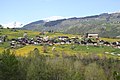
 Camuns
 -
 Surcasti
 -
 Tersnaus
 -
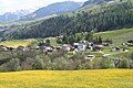 Uors
Uors -
 The church of Tersnaus
 -
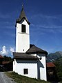 The church of Peiden


Other websites[change | change source]
![]() Media related to Suraua at Wikimedia Commons
Media related to Suraua at Wikimedia Commons
- www.suraua.ch
- Suraua in German, French and Italian in the online Historical Dictionary of Switzerland.
- Camuns in German, French and Italian in the online Historical Dictionary of Switzerland.
- Tersnaus in German, French and Italian in the online Historical Dictionary of Switzerland.
- Uors in German, French and Italian in the online Historical Dictionary of Switzerland.
- Peiden in German, French and Italian in the online Historical Dictionary of Switzerland.
- Uors-Peiden in German, French and Italian in the online Historical Dictionary of Switzerland.