Tarlac
Appearance
Tarlac Province
Lalawigan ng Tarlac | |
|---|---|
| Province of Tarlac | |
| Nickname(s): Melting Pot Of Central Luzon Sugar Capital Of Luzon | |
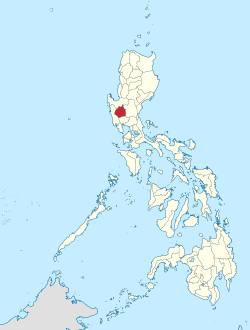
 Map of the Philippines with Tarlac highlighted | |
| Coordinates: 15°30′N 120°30′E / 15.500°N 120.500°E | |
| Country | |
| Region | Central Luzon (Region III) |
| Founded | 1872 |
| Capital | Tarlac City |
| Government | |
| • Type | Province of the Philippines |
| • Governor | Victor Yap (NPC) |
| • Vice Governor | Pearl Angeli Pacada (Lakas-Kampi-CMD) |
| Area | |
| • Total | 2,736.6 km2 (1,056.6 sq mi) |
| • Rank | 49th out of 80 |
| Population (2010) | |
| • Total | 1,273,240 |
| • Rank | 17th out of 80 |
| • Density | 470/km2 (1,200/sq mi) |
| • Rank | 12th out of 80 |
| Divisions | |
| • Independent cities | 0 |
| • Component cities | 1 |
| • Municipalities | 17 |
| • Barangays | 511 |
| • Districts | 1st to 3rd districts of Tarlac |
| Time zone | UTC+8 (PHT) |
| ZIP Code | 2300 |
| Spoken languages | Kapampangan, Tagalog, Ilocano, Pangasinan, English |
Tarlac (Tagalog: Lalawigan ng Tarlac) is a landlocked province of the Philippines in Central Luzon. Tarlac is surrounded by Pampanga at the south, Nueva Ecija at the east, Pangasinan at the north and Zambales at the west. It is a part of Central Luzon. Tarlac is populated by 1,273,240 people as of 2010.[1]
References
[change | change source]- ↑ "Total Population by Province, City, Municipality and Barangay: as of May 1, 2010" (PDF). Philippine Census. 1 May 2010. Archived from the original (PDF) on 15 November 2012. Retrieved 16 March 2013.
Other websites
[change | change source]Wikimedia Commons has media related to Tarlac.
- Executive Order No. 561: FORMATION OF THE "SUPER" REGIONS AND MANDATE OF THE SUPERREGIONAL DEVELOPMENT CHAMPIONS Archived 2008-09-17 at the Wayback Machine
- North Luzon Super Region: Potentials Archived 2007-06-15 at the Wayback Machine
- North Luzon Super Region: Projects Archived 2007-06-15 at the Wayback Machine


