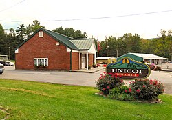
Unicoi, Tennessee
Unicoi, Tennessee | |
|---|---|
 Unicoi Town Hall | |
 Location of Unicoi, Tennessee | |
| Coordinates: 36°13′12″N 82°20′17″W / 36.22000°N 82.33806°W | |
| Country | United States |
| State | Tennessee |
| County | Unicoi |
| Incorporated | 1994[1] |
| Named for | Unaka, Cherokee for "white"[2] |
| Area | |
| • Total | 16.19 sq mi (41.93 km2) |
| • Land | 16.19 sq mi (41.93 km2) |
| • Water | 0.00 sq mi (0.00 km2) |
| Elevation | 1,923 ft (586 m) |
| Population | |
| • Total | 3,833 |
| • Density | 236.75/sq mi (91.41/km2) |
| Time zone | UTC-5 (Eastern (EST)) |
| • Summer (DST) | UTC-4 (EDT) |
| ZIP code | 37692 |
| Area code | 423 |
| FIPS code | 47-75820[5] |
| GNIS feature ID | 1304219[6] |
| Website | www |
Unicoi is a town in Unicoi County, Tennessee, United States. The population was 3,632 at the 2010 census and 3,833 at the 2020 census.[4] It is part of the Johnson City Metropolitan Statistical Area.
It is a component of the Johnson City–Kingsport–Bristol, TN-VA Combined Statistical Area – commonly known as the "Tri-Cities" region.
References[change | change source]
- ↑ Tennessee Blue Book, 2005-2006, pp. 618-625.
- ↑ Nancy Capace, Encyclopedia of Tennessee (North American Book Distributors, 2000), p. 226.
- ↑ "ArcGIS REST Services Directory". United States Census Bureau. Retrieved October 15, 2022.
- ↑ 4.0 4.1 "Profile of General Population and Housing Characteristics: 2020 Demographic Profile Data (DP-1): Unicoi town, Tennessee". United States Census Bureau. Retrieved March 18, 2024.
- ↑ "U.S. Census website". United States Census Bureau. Retrieved 2008-01-31.
- ↑ "US Board on Geographic Names". United States Geological Survey. 2007-10-25. Retrieved 2008-01-31.
