
User:Immanuelle/Iwase-Senzuka Kofun Cluster
| 岩橋千塚古墳群 | |
 Iwase-Senzuka Kofun Cluster | |
| Lua error in Module:Location_map at line 525: Unable to find the specified location map definition: "Module:Location map/data/Japan Wakayama Prefecture" does not exist. | |
| Location | Wakayama, Japan |
|---|---|
| Region | Kansai region |
| Coordinates | 34°13′29.8″N 135°13′40.6″E / 34.224944°N 135.227944°E |
| Type | Kofun cluster |
| History | |
| Founded | 4th to 7th century AD |
| Periods | Kofun period |
| Site notes | |
| Public access | Yes (museum at sie) |
| This is not a Wikipedia article: It is one user's draft page that he or she is working on. It may be incomplete and/or unreliable. This page was last edited by Immanuelle (talk | contribs) 0 seconds ago. |
| The English used in this user page may not be easy for everybody to understand. You can help Wikipedia by reading Wikipedia:How to write Simple English pages, then simplifying the page. |
_%E5%87%BA%E5%9C%9F%E5%93%81-1.JPG)
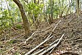
Iwase-Senzuka Kofun Cluster (岩橋千塚古墳群, Iwase-Senzuka kofun gun) [1]) is a cluster of Kofun period burial mounds that is located in the Wakayama, in the Kansai region of Japan.[2] One of the largest concentrations of burial mounds in Japan, it consist of over 900 tumuli.[3][4] It is designated as a National Historic Site in 1931, upgraded to a Special National Historic Site in 1952, and the area under designation expanded in 2016.[5]
Overview[change | change source]
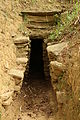
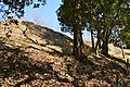
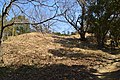
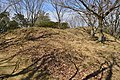
The site is located in the eastern portion of the city of Wakayama,on an east-west extension of the Ryumon Mountains, and west of Yada Pass. It consists of a group of ancient burial mounds related to the kuni no miyatsuko of Kii Province, and consists of approximately 900 kofun, making it one of the largest sites in Japan. These tumuli are divided between the Hanayama branch in the Narugami district in the north and the Ibe Hachiman burial mound in the Okazaki district in the south. In the western portion of the site are the Hinokuma Shrine and Kunikakasu Shrine, which enshrine the spirits of the kuni no miyatsuko. The kofun consist mostly of circular type (empun (円墳)) and square-type (hōfun (方墳)), with only one percent as zenpō-kōen-fun (前方後円墳), which are shaped like a keyhole, having one square end and one circular end, when viewed from above. It is believed that these tumuli were all constructed from around the middle of the 4th century, until the proclamation of the Taika Reforms in the middle of the 7th century. With regards to the burial facilities, the earliest kofun had clay-lined burial chambers with box-type sarcophagus. This evolved into chlorite schist-lined stone chambers for later burials. The schist was separated into slabs, which were stacked to form the walls, into which several stone beams were embedded for structural integrity, and the ceiling was covered with large stones.[6]
Excavations began in 1906, and have been ongoing intermittently to then present day. Many of the finds from the site are on display at the Kiifudoki-no-oka Museum of History.[6]
Gallery[change | change source]
-
 Maeyama Kofun A13 Corridor from the entrance to the burial chamber
 -
 Maeyama Kofun A46 Burial chamber
 -
 Maeyama Kofun A56 Entrance area to the stone chamber
 -
 Maeyama Kofun A100 Stone coffin made from stone slabs
 -
 Maeyama Kofun A111 Shaft-like stone chamber
 -
 Maeyama Kofun B53, Shōgun-zuka Kofun
 -
 Maeyama Kofun B53, Stone chamber of the Shogunzsuka Kofun
 -
 Maeyama Kofun B67, Chijizuka Kofun
 -
 Maeyama Kofun B112, Gunchōzuka Kofun
 -
 Stone chamber of the Tennōzuka Kofun
 -
 Hanayama Kofun 6 Tumulus
 -
 Hanayama Kofun 6 Stone chamber
 -
 Inbe Maeyama Kofun B10, Inbe Hachiman-yama Kofun


,_funkyu-2.jpg)
,_genshitsu-1.jpg)


,_genshitsu-2.jpg)


See also[change | change source]
References[change | change source]
- ↑ "岩橋千塚古墳群 文化遺産オンライン". bunka.nii.ac.jp. Retrieved 2021-07-24.
- ↑ "岩橋千塚古墳群の概要". www.kiifudoki.wakayama-c.ed.jp. Retrieved 2021-07-24.
- ↑ 国指定史跡ガイド,百科事典マイペディア. "岩橋千塚古墳群とは". コトバンク (in Japanese). Retrieved 2021-07-24.
- ↑ 小項目事典,世界大百科事典内言及, 日本大百科全書(ニッポニカ),ブリタニカ国際大百科事典. "岩橋千塚とは". コトバンク (in Japanese). Retrieved 2021-07-24.
{{cite web}}: CS1 maint: multiple names: authors list (link) - ↑ "国指定文化財等データベース". kunishitei.bunka.go.jp. Retrieved 2021-07-24.
- ↑ 6.0 6.1 Isomura, Yukio; Sakai, Hideya (2012). (国指定史跡事典) National Historic Site Encyclopedia. 学生社. ISBN 4311750404.(in Japanese)
External links[change | change source]
- "岩橋千塚古墳群の概要". www.kiifudoki.wakayama-c.ed.jp. Retrieved 2021-07-24.
- "国指定文化財等データベース". kunishitei.bunka.go.jp. Retrieved 2021-07-24.