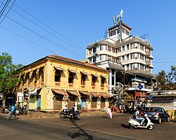
Vasco da Gama, Goa
Vasco da Gama | |
|---|---|
 A view of the city | |
| Coordinates: 15°23′53″N 73°48′40″E / 15.39806°N 73.81111°E | |
| Country | |
| State | Goa |
| District | South Goa |
| Sub-district | Mormugao |
| Named for | Vasco da Gama |
| Elevation | 43 m (141 ft) |
| Population (2011) | |
| • Total | 100,000[1] |
| Time zone | UTC+5:30 (IST) |
| PIN | 403802 |
| Area code | 91-832 |
| Vehicle registration | GA-06 |
| Website | www |
Vasco da Gama (/ˌvæskoʊ də ˈɡæmə/), often shortened to Vasco, is a city in the state of Goa on the west coast of India. It is named after the Portuguese explorer Vasco da Gama. It is the headquarters of the Mormugão taluka (subdistrict). The city lies on the western tip of the Mormugao peninsula, at the mouth of the Zuari River, about 30 kilometres (19 mi) from Panaji, Goa's capital, and about 5 kilometres (3.1 mi) from Dabolim Airport.
The city was founded in 1543 and remained in Portuguese hands until 1961, when it became part of India. The 1888 constructed Mormugao Port remains a busy shipping route in Asia. It is one of the major ports of independent India.[2] The ship-building area of Goa Shipyard Limited that builds Navy and Coast Guard vessels was also built here in 1957 (during the Portuguese-era). Initially built around the city's harbour as the barge-repair yard Estaleiros Navais de Goa, the area has now[when?] expanded to include more related activities.[source?] The Indian Navy also has a presence in Mormugao, with its vast campuses, which include the naval base INS Hansa that shares control over the Dabolim Airport enclave.[3]
References
[change | change source]- ↑ "Maps of India-Vasco da Gama". Retrieved 2017-03-01.
- ↑ "Major ports cargo traffic up 4.83% in Apr–Nov". The Hindu: Business Line. Dec 10, 2018. Retrieved 2018-12-12.
- ↑ "Goa airport's runway deteriorating, may affect operations: Indian Navy". Hindustan Times. 2018-05-11. Retrieved 2018-12-12.


