Vertus
Vertus | |
|---|---|
Part of Blancs-Coteaux | |
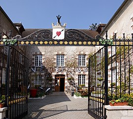
 The town hall in Vertus | |
| Coordinates: 48°54′19″N 4°00′08″E / 48.9054°N 4.0021°E | |
| Country | France |
| Region | Grand Est |
| Department | Marne |
| Arrondissement | Épernay |
| Canton | Vertus-Plaine Champenoise |
| Commune | Blancs-Coteaux |
| Area 1 | 35.68 km2 (13.78 sq mi) |
| Population (2019)[1] | 2,345 |
| • Density | 66/km2 (170/sq mi) |
| Demonym | Vertusiens |
| Time zone | UTC+01:00 (CET) |
| • Summer (DST) | UTC+02:00 (CEST) |
| Postal code | 51130 |
| Elevation | 98–247 m (322–810 ft) |
| 1 French Land Register data, which excludes lakes, ponds, glaciers > 1 km2 (0.386 sq mi or 247 acres) and river estuaries. | |
Vertus is a former commune. It is in Grand Est in the Marne department in northeast France. On 1 January 2018, it was merged into the new commune of Blancs-Coteaux.[2]
Related pages[change | change source]
References[change | change source]
- ↑ Téléchargement du fichier d'ensemble des populations légales en 2019, INSEE
- ↑ Arrêté préfectoral 21 December 2017 (in French)
Wikimedia Commons has media related to Vertus.


