Zirndorf
Zirndorf | |
|---|---|
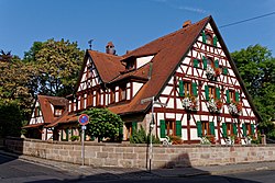
 Former House of Lords built in 1696 | |
| Coordinates: 49°27′N 10°57′E / 49.450°N 10.950°E | |
| Country | Germany |
| State | Bavaria |
| Admin. region | Mittelfranken |
| District | Fürth |
| Subdivisions | 12 Stadtteile |
| Government | |
| • Mayor (2020–26) | Thomas Zwingel[1] (SPD) |
| Area | |
| • Total | 28.78 km2 (11.11 sq mi) |
| Elevation | 306 m (1,004 ft) |
| Population (2022-12-31)[2] | |
| • Total | 26,234 |
| • Density | 910/km2 (2,400/sq mi) |
| Time zone | UTC+01:00 (CET) |
| • Summer (DST) | UTC+02:00 (CEST) |
| Postal codes | 90513 |
| Dialling codes | 0911, 09127 (Wintersdorf, Weinzierlein) |
| Vehicle registration | FÜ |
| Website | www.zirndorf.de |
Zirndorf (German pronunciation: [ˈt͡sɪʁndɔʁf] (![]() listen)) is a town, which is part of Fürth. It is in northern Bavaria, Germany in the Regierungsbezirk of Middle Franconia.
listen)) is a town, which is part of Fürth. It is in northern Bavaria, Germany in the Regierungsbezirk of Middle Franconia.


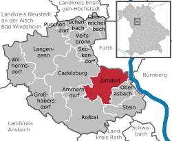
Neighbouring municipalities[change | change source]
The following towns and municipalities share borders with Zirndorf; they are listed in clockwise order, starting in the north:
References[change | change source]
- ↑ Liste der ersten Bürgermeister/Oberbürgermeister in kreisangehörigen Gemeinden, Bayerisches Landesamt für Statistik, 15 July 2021.
- ↑ Genesis Online-Datenbank des Bayerischen Landesamtes für Statistik Tabelle 12411-003r Fortschreibung des Bevölkerungsstandes: Gemeinden, Stichtag (Einwohnerzahlen auf Grundlage des Zensus 2011)
Other websites[change | change source]
- Official Website (in German)


