Abingdon, Virginia
Abingdon, Virginia | |
|---|---|
| Motto(s): Honor Pro Antiquis, Fides Pro Futuris | |
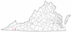
 Location in the Commonwealth of Virginia | |
| Coordinates: 36°42′35″N 81°58′32″W / 36.70972°N 81.97556°W | |
| Country | United States |
| State | Virginia |
| County | Washington |
| Founded | 1776 |
| Government | |
| • Mayor | Derrick Webb |
| Area | |
| • Total | 8.3 sq mi (21.6 km2) |
| • Land | 8.3 sq mi (21.6 km2) |
| • Water | 0 sq mi (0 km2) |
| Elevation | 2,087 ft (636 m) |
| Population (2020) | |
| • Total | 8,376 |
| • Density | 1,039/sq mi (377.38/km2) |
| Time zone | UTC-5 (EST) |
| • Summer (DST) | UTC-4 (EDT) |
| ZIP codes | 24210-24212 |
| Area code | 276 |
| FIPS code | 51-00148[1] |
| GNIS feature ID | 1498444[2] |
| Website | http://www.abingdon.com/ |
Abingdon is a town in Washington County, Virginia, 133 miles (214 km) southwest of Roanoke.
References[change | change source]
- ↑ "American FactFinder". United States Census Bureau. Retrieved 2008-01-31.
- ↑ "US Board on Geographic Names". United States Geological Survey. 2007-10-25. Retrieved 2008-01-31.

