Pind Kargu Khan
Pind Kargu Khan | |
|---|---|
| Pind Kargu Khan | |
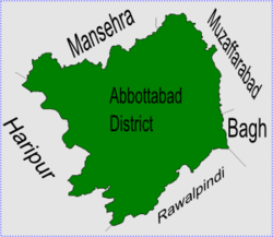
 Pind Kargo Khan is in Abbottabad District | |
| Coordinates: 34°N 73°E / 34°N 73°E | |
| Country | |
| Province | Khyber Pakhtunkhwa |
| District | Abbottabad |
| Tehsil | Abbottabad |
| Government | |
| • Nazim | Tanoli[1] |
| • Naib Nazim | Sultan Muhammad Khan |
| Population | |
| • Total | 12,000 |
Pind Kargu Khan is one of the 51 Union Councils of Abbottabad District in the Khyber Pakhtunkhwa province of Pakistan [2] it is 28 km from Abbottabad city.
The huge forest of pine tree named Kohe-e-Balehana is located on the peak of Sando Gali, most of the people are farming - the main crops are maze and wheat. It has a beautiful valley with the flower of Rose, Chambali (Jasmine), Sunflower.
The main fruits are Apricot, Grapes, Pomegranate, Watermelon, Pear, Guava, Lemon, Locate, Peach, Apple, strawberry etc.
Subdivisions[change | change source]
The Union Council is subdivided into the following areas: Bacha Kalan, Bacha Khurd, Bandi Nikra, Bareela, Barkot, Chahar, Chatha, Gandah, Haal, Kanger Bala, Kangrora, Khalora Tarla, Khalora Utla, Khanda Khoo, Lakhala, Pind, Pind Kargu Khan, Kotha Doga, Dhakian, Beesala, Marmanian, Rakran, Amliala, Loola, Kotera, Jabri, Bandi, Chharat, Bagarian, Sando Gali, Chhajian, Badyal, Sohaie, Baliana, Chanjeela, meherh, Ghumanian, Tredda, Khukhri, Sahra, Darra, Manna, Sarran, Pohar, Rata, Nazran, Mankran, Sharula, Sahi Parrian, Sari, Sher Shah and Tandhara[1]
References[change | change source]
- ↑ 1.0 1.1 Pind Kargu Khan Union Council[permanent dead link]
- ↑ "Administrative Units of District Abbottabad". Archived from the original on 2007-04-03. Retrieved 2008-08-01.
