
Abergavenny
Abergavenny
| |
|---|---|
 Abergavenny Museum | |
 Abergavenny | |
| Location within Monmouthshire | |
| Population | 12,515 (2011) |
| OS grid reference | SO295145 |
| Principal area | |
| Ceremonial county | |
| Country | Wales |
| Sovereign state | United Kingdom |
| Post town | ABERGAVENNY |
| Postcode district | NP7 |
| Dialling code | 01873 |
| Police | Gwent |
| Fire | South Wales |
| Ambulance | Welsh |
| UK Parliament | |
Abergavenny (Welsh: Y Fenni) is a market town and community in Monmouthshire, Wales. As of 2011, Avergavenny had a population of 12,515. The town is promoted as The Gateway to Wales.[1]
Transport
[change | change source]Abergavenny railway station is a train station on the Welsh Marches line. Passengers at the station can board direct trains to places such as Hereford, Shrewsbury, Manchester, Chester, Wrexham, Holyhead, Cardiff, Swansea and Carmarthen.
Gallery
[change | change source]-
 Abergavenny Market Hall clock tower
 -
 St Mary's Priory Church
 -
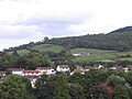 Part of Abergavenny seen from the castle ruins


References
[change | change source]- ↑ "Visit Abergavenny – The Gateway to Wales". Visit Abergavenny. Retrieved 30 January 2020.
| International | |
|---|---|
| National | |
| Geographic | |