Båtsfjord
Båtsfjord kommune
Báhcavuona gielda | |
|---|---|
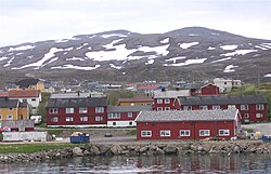
 View of Båtsfjord village | |
 Båtsfjord within | |
| Coordinates: 70°38′07″N 29°43′15″E / 70.63528°N 29.72083°E | |
| Country | Norway |
| Established | 1839 |
| Administrative centre | Båtsfjord |
| Area | |
| • Total | 1,434.78 km2 (553.97 sq mi) |
| • Land | 1,416.05 km2 (546.74 sq mi) |
| • Water | 18.73 km2 (7.23 sq mi) 1.3% |
| • Rank | 63 in Norway |
| Population (2022) | |
| • Total | 2,165 |
| • Rank | 269 in Norway |
| • Density | 1.5/km2 (4/sq mi) |
| Time zone | UTC+01:00 (CET) |
| • Summer (DST) | UTC+02:00 (CEST) |
| ISO 3166 code | NO-5443 |
| Preceded by | Vardø Municipality |
Båtsfjord, or Báhcavuonna, is a municipality in Norway's northernmost county, Finnmark.
Settlements include Båtsfjord (settlement).
Administration[change | change source]
The municipal council is elected until late 2027.
- 6 council members are from Labour party [1]
- 5 from Båtsfjordlista
- 4 from Centre party
(The 15 council members were elected during the 2023 Norwegian local elections.)
Related pages[change | change source]
References[change | change source]
- ↑ https://www.nrk.no/valg/2023/resultat/fylke/56/5632. NRK.no. Retrieved 2023-09-27


