Baldwin, Maine
Appearance
Baldwin, Maine | |
|---|---|
 Pequawket Trail c. 1906 | |
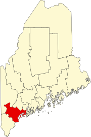
 Location in Cumberland County and the state of Maine. | |
| Coordinates: 43°49′24″N 70°43′27″W / 43.82333°N 70.72417°W | |
| Country | United States |
| State | Maine |
| County | Cumberland |
| Incorporated | 1802 |
| Named for | Loammi Baldwin |
| Villages | Cornish Station East Baldwin North Baldwin West Baldwin |
| Area | |
| • Total | 36.35 sq mi (94.15 km2) |
| • Land | 35.32 sq mi (91.48 km2) |
| • Water | 1.03 sq mi (2.67 km2) |
| Elevation | 679 ft (207 m) |
| Population (2020) | |
| • Total | 1,520 |
| • Density | 43/sq mi (16.6/km2) |
| Time zone | UTC-5 (Eastern (EST)) |
| • Summer (DST) | UTC-4 (EDT) |
| Area code | 207 |
| FIPS code | 23-02655 |
| GNIS feature ID | 0582338 |
| Website | www |
Baldwin is a town in Cumberland County, Maine, United States. The population was 1,520 at the 2020 census.[2] It is part of the Portland–South Portland–Biddeford, Maine, metropolitan statistical area.
References
[change | change source]- ↑ "2020 U.S. Gazetteer Files". United States Census Bureau. Retrieved February 14, 2024.
- ↑ "Profile of General Population and Housing Characteristics: 2020 Demographic Profile Data (DP-1): Baldwin town, Maine". United States Census Bureau. Retrieved February 14, 2024.


